MAKE A MEME
View Large Image
| View Original: | 1658_Jansson_Map_of_the_Indian_Ocean_(Erythrean_Sea)_in_Antiquity_-_Geographicus_-_ErythraeanSea-jansson-1658.jpg (5000x4194) | |||
| Download: | Original | Medium | Small | Thumb |
| Courtesy of: | commons.wikimedia.org | More Like This | ||
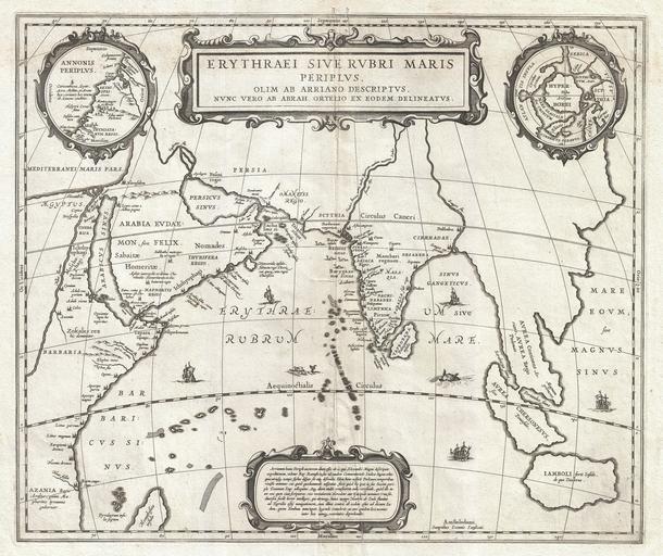
| Keywords: 1658 Jansson Map of the Indian Ocean (Erythrean Sea) in Antiquity - Geographicus - ErythraeanSea-jansson-1658.jpg Artwork of the region heavily on records from Alexander the Great's conquests Two smaller maps in the upper left and right quadrants are of exceptional interest The upper left chart shows northwestern Africa and is titled Annonis Periplus This is a reference to the legendary expeditions of the Carthaginian King Hanno said to have been the first to access the Indian Ocean by sailing around the southern tip of Africa Incidentally en route he is also said to have been the first to tame a lion The upper right chart shows the northern polar regions as they were perceived at the time A landmass covering the polar ice cap is indentified as Hyperborea To the left of this roughly where North America rests today the island of Atlantis appears; while Scythia Europe Thule and Asia are on the right Greenland and possibly Iceland appear at the bottom This map is intended to point out the possibility of a Northeast Passage to Asia which was at the time being actively sought after by Dutch English and Russian navigators Both smaller maps the primary title area at top center and an Latin explanation for the map at bottom center are surrounded by baroque strapwork style borders This remarkable map was published in volume six the Orbis Antiquus of Jan Jansson's Novus Atlas 1658 undated Size in 19 16 object history credit line accession number ErythraeanSea-jansson-1658 Jansson J <i>Novus Atlas Sive Theatrum Orbis Terrarum In quo Orbis Antiquus Seu Geographia Vetus Sacra Profana exhibetur</i> Volume 6 1658 Geographicus-source PD-old-100 Maps by Jan Jansson Old maps of the Indian Subcontinent Old maps of the Arctic 1650s maps of Africa Maps in Latin Old maps of phantom islands Old maps of the Indian Ocean 1658 maps of India Periplus of the Erythraean Sea | ||||
_in_Antiquity_-_Geographicus_-_ErythraeanSea-jansson-1658.jpg)