MAKE A MEME
View Large Image
| View Original: | 1763_Bellin_Map_of_Cape_Town_(_Cape_of_Good_Hope_)_South_Africa_-_Geographicus_-_GoodHope2-bellin-1763.jpg (2077x2600) | |||
| Download: | Original | Medium | Small | Thumb |
| Courtesy of: | commons.wikimedia.org | More Like This | ||
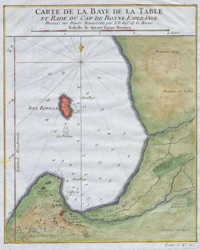
| Keywords: 1763 Bellin Map of Cape Town ( Cape of Good Hope ) South Africa - Geographicus - GoodHope2-bellin-1763.jpg This hand colored map is a c 1763 map of the Cape of Good Hope and Cape Town South Africa Attributed to French cartographer Jacques-Nicholas Bellin this map was issued for the French edition of Provost ™s Histoire des Voyages ¦ Beautifully rendered mountains and villages show the area in considerable detail Shows the Village of the Hottentots Blue Mountain Cow Mountain Table Mountain The City of Cape Town itself Tigerbergen and many other features Some oceanic depths are indicated Of interest is also the Isle of Robben located centrally on the map Long a place of exile and punishment this island prison had a reputation for brutality and cruelty Today a museum honors the site of so much suffering 1763 Size in 9 7 object history credit line accession number GoodHope2-bellin-1763 Geographicus-source PD-old-100 Cape Town in the 18th century Old maps of Cape Town 1763 maps Cape of Good Hope French language maps of Africa Old maps of South Africa Maps of Robben Island Maps by Jacques-Nicolas Bellin Maps of South Africa French language maps of South Africa 1763 Bellin Map of Cape Town (Cape of Good Hope) South Africa - Geographicus - GoodHope2-bellin-1763.jpg This hand colored map is a c 1763 map of the Cape of Good Hope and Cape Town South Africa Attributed to French cartographer Jacques-Nicholas Bellin this map was issued for the French edition of Provost ™s Histoire des Voyages ¦ Beautifully rendered mountains and villages show the area in considerable detail Shows the Village of the Hottentots Blue Mountain Cow Mountain Table Mountain The City of Cape Town itself Tigerbergen and many other features Some oceanic depths are indicated Of interest is also the Isle of Robben located centrally on the map Long a place of exile and punishment this island prison had a reputation for brutality and cruelty Today a museum honors the site of so much suffering 1763 Size in 9 7 object history credit line accession number GoodHope2-bellin-1763 Geographicus-source PD-old-100 Cape Town in the 18th century Old maps of Cape Town 1763 maps Cape of Good Hope French language maps of Africa Old maps of South Africa Maps of Robben Island Maps by Jacques-Nicolas Bellin Maps of South Africa French language maps of South Africa | ||||
_South_Africa_-_Geographicus_-_GoodHope2-bellin-1763.jpg)