MAKE A MEME
View Large Image

| View Original: | 1775_Bonne_Map_of_Peru,_Ecuador,_Bolivia,_and_the_Western_Amazon_-_Geographicus_-_PeruQuito-bonne-1775.jpg (2551x3500) | |||
| Download: | Original | Medium | Small | Thumb |
| Courtesy of: | commons.wikimedia.org | More Like This | ||
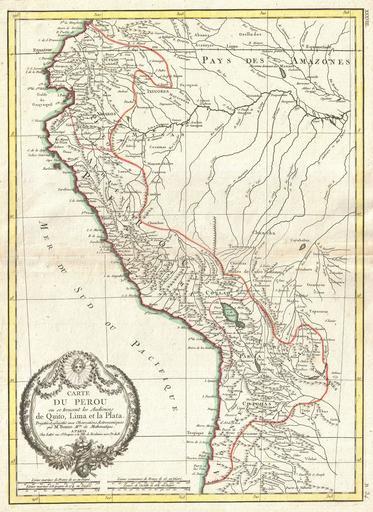
| Keywords: 1775 Bonne Map of Peru, Ecuador, Bolivia, and the Western Amazon - Geographicus - PeruQuito-bonne-1775.jpg A beautiful example of Jan Janvier's 1762 decorative map of Peru Covers the western parts of South America from just north of the Equator south as far as the Tropic of Capricorn Includes the modern day nations of Peru Ecuador here called Quito Bolivia and parts of adjacent Brazil Columbia Chile and Argentina Offers excellent detail throughout showing mountains rivers national boundaries cities regions and tribes Curiously this map identifies the Ancienne demeure des Manaos This was once a great trading empire was centered along the Rio Negro in the Amazon Basin The Manoa traded from Peru to the Orinoco There were perhaps most famously encountered by Sir Walter Raleigh in Guyana while on an annual trading expedition to the region Raleigh seeing the gold artifacts carried by the traders immediately assumed they must be from El Dorado He asked local tribesmen who they were and where they came from The locales responded that they crossed a great lake and came from a rich land called Manoa Though at the time Raleigh did not explore this further he did later write that he discovered the great city of Manoa capital of El Dorado on a vast lake in Guyana No doubt Raleigh intended to return to South America but was prevented from doing so by his unfortunate beheading back in England As a result of Raleigh's guess work the Lake of Parima and city of Manoa would appear for several hundred years on maps of northern South America A large decorative title cartouche appears in the lower left quadrant Drawn by R Bonne c 1775 for issue as plate no B 34 in Jean Lattre's 1776 issue of the Atlas Moderne 1775 undated Size in 13 17 75 object history credit line accession number PeruQuito-bonne-1775 Lattre Jean <i>Atlas Moderne ou Collection de Cartes sur Toutes les Parties du Globe Terrestre</i> c 1775 Geographicus-source PD-old-100 | ||||