MAKE A MEME
View Large Image
| View Original: | 1775_Zannoni_Two_Panel_Map_of_France_-_Geographicus_-_France-zannoni-1775.jpg (3996x5000) | |||
| Download: | Original | Medium | Small | Thumb |
| Courtesy of: | commons.wikimedia.org | More Like This | ||
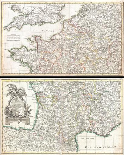
| Keywords: 1775 Zannoni Two Panel Map of France - Geographicus - France-zannoni-1775.jpg A beautiful example of Zannoni's 1775 decorative two panel map of France Lower sheet covers from Valladolid Spain eastwards as far as Piedmont and northwards as far s Navernois Northern sheet covers from Bretagne eastward as far as Switzerland and north as far as the Hague Includes the Channel Islands and the southern Part of England and Wales A decorative title cartouche appears in the lower left quadrant of the southern plate Drawn by Zannoni c 1775 for issue as plate nos 4-5 in Jean Lattre's 1776 issue of the Atlas Moderne 1775 undated Size in 20 5 12 5 object history credit line accession number France-zannoni-1775 Lattre Jean <i>Atlas Moderne ou Collection de Cartes sur Toutes les Parties du Globe Terrestre</i> c 1775 Geographicus-source PD-Art-100 Old maps of the history of France 1775 maps Giovanni Antonio Rizzi Zannoni Maps in French | ||||