MAKE A MEME
View Large Image
| View Original: | 1790_Faden_Map_of_the_Roads_of_Great_Britain_or_England_-_Geographicus_-_England-faden-1790.jpg (4000x5003) | |||
| Download: | Original | Medium | Small | Thumb |
| Courtesy of: | commons.wikimedia.org | More Like This | ||
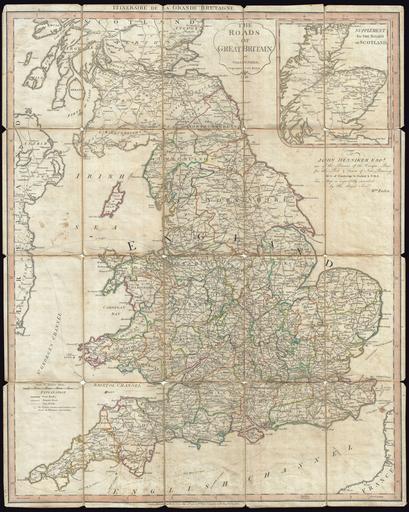
| Keywords: 1790 Faden Map of the Roads of Great Britain or England - Geographicus - England-faden-1790.jpg A very attractive example of Faden's desirable Roads of Great Britain in its second edition 1790 Covering from Scotland to Cornwall this large pocket map was designed with the traveler in mind showing most of the major and minor roads in England In the upper right quadrant there is a smaller inset map showing the roadways of Scotland This map first appeared in 1781 and was published in several editions first by Faden then by his successor Wyld until about 1833 Faden dedicated this map to John Henniker Baron of Worlingsworth Hall and a member of Parliament representing New Romney New Romney was one of the Cinque Ports a series of important shipping ports along the coast of Kent and Sussex where the English Channel was narrowest Faden clearly hoped that Henniker's position as MP for New Romney would see his Roads of Great Britain distributed to the many teamsters who came and went from the port Faden must have been at least partially correct as this map enjoyed a long and popular run in numerous editions 1790 dated Size in 23 5 30 5 object history credit line accession number England-faden-1790 Geographicus-source PD-Art-100 Maps by William Faden Old maps of Great Britain Road maps of the United Kingdom 1790 maps English language maps of Europe | ||||