MAKE A MEME
View Large Image
| View Original: | 1794_Samuel_Dunn_Wall_Map_of_the_World_in_Hemispheres_-_Geographicus_-_World2-dunn-1794.jpg (6000x5054) | |||
| Download: | Original | Medium | Small | Thumb |
| Courtesy of: | commons.wikimedia.org | More Like This | ||
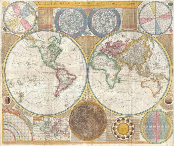
| Keywords: 1794 Samuel Dunn Wall Map of the World in Hemispheres - Geographicus - World2-dunn-1794.jpg Artwork s as well as northern and southern hemisphere star charts a map of the Moon a Latitude and Longitude Analemma chart a map of the Solar System a Mercator projection of the world an Analemma projection a seasonal chart a universal scale chart and numerous smaller diagrams depicting planets and mathematical systems All text is in English We will start our survey of this map in North America much of which was even in 1794 largely unknown This map follows shortly after the explorations of Captain Cook in the Arctic and Pacific Northwest so the general outline of the continent is known However when this map was made few inland expeditions had extended westward beyond the Mississippi This map notes two separate speculative courses for the apocryphal River of the West a northern route extending from Lake Winnipeg and a southern route passing south of Winnepeg through Pike's lake The River of the West was hopeful dream of French and English explorers who were searching for a water passage through North America to the Pacific In concept should such a route be found it would have become an important trade artery allowing the British and French who's colonies dominated the eastern parts of North America to compete with the Spanish for control of the lucrative Asia-Pacific trade Little did these earlier speculative cartographers realize the bulk of the Rocky Mountains stood between them and their dreams Slightly south of the Rivers of the West we find the kingdom of Quivira which is one of the lands associated with Spanish legends of the Seven Cities of Gold In this area we can also find Drake's Harbor or Port de la Bodega and Albion Drake's Harbor is where Sir Francis Drake supposedly landed during his circumnavigation of the globe in 1580 Drake wintered in this harbor and used the abundant resources of the region to repair his ships He also claimed the lands for England dubbing them New Albion Although the true location of Drake's port is unknown most place it much further to the north By situating it and consequently New Albion further to the south Dunn is advocating a British rather than Spanish claim to this region On the Eastern coast of North America we find a fledgling United States extending from Georgia to Maine Dunn names Boston New York Charleston Long Island and Philadelphia as well as the important smaller towns of Jamestown Williamsburg and Edonton South America exhibits a typically accurate coastline and limited knowledge of the interior beyond Peru and the populated coastlands A few islands are noted off the coast including the Galapagos which are referred to as the Inchanted Islands The Amazon is vague with many of its tributaries drawn in speculatively Dunn and d'Anville have done away with the popular representation of Manoa or El Dorado in Guyana but a vestigial Lake Parima is evident Further south the Laguna de los Xarayes another apocryphal destination is drawn at the northernmost terminus of the Paraguay River The Xaraiés meaning Masters of the River were an indigenous people occupying what are today parts of Brazil's Matte Grosso and the Pantanal When Spanish and Portuguese explorers first navigated up the Paraguay River as always in search of El Dorado they encountered the vast Pantanal flood plain at the height of its annual inundation Understandably misinterpreting the flood plain as a gigantic inland sea they named it after the local inhabitants the Xaraies 1794 dated Size in 49 42 object history credit line accession number World2-dunn-1794 Kitchin Thomas <i>Kitchin's General Atlas describing the Whole Universe being a complete collection of the most approved maps extant; corrected with the greatest care and augmented from the last edition of D'Anville and Robert with many improvements by other eminent geographers engraved on Sixty-Two plates comprising Thirty Seven maps </i> Laurie Whittle London 1797 Geographicus-source PD-old-100 Assessments 1 1 Maps by Samuel Dunn 1794 maps Old maps of Earth's hemispheres Old constellation maps Old maps of the Moon Solar System Chart Old maps with Mercator projection English language maps of Earth Astronomical diagrams Featured maps Featured pictures of England | ||||