MAKE A MEME
View Large Image
| View Original: | 1801_Cary_Map_of_Scotland_(4_Sheets)_-_Geographicus_-_Scotland-cary-1801.jpg (7000x6322) | |||
| Download: | Original | Medium | Small | Thumb |
| Courtesy of: | commons.wikimedia.org | More Like This | ||
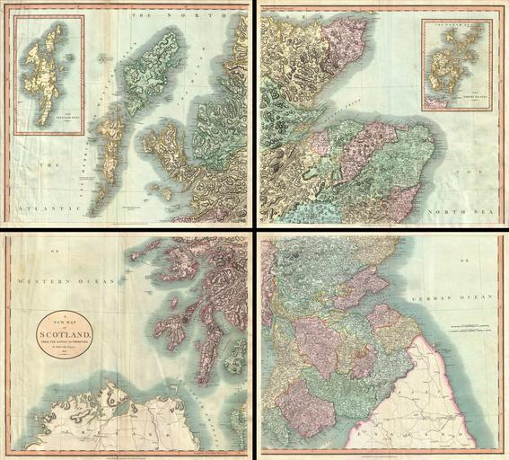
| Keywords: 1801 Cary Map of Scotland (4 Sheets) - Geographicus - Scotland-cary-1801.jpg A very attractive example of John Cary ™s stupendous four sheet 1801 map of Scotland Covers the entirety of Scotland as well as parts of neighboring England and Ireland Inset maps detail the Orkney Islands and the Shetland Islands Offers extraordinary detail on the whole of Scotland with special attention to topography historical notations and roadways Note mileage Four sheets designed to be united into a single massive wall map of Scotland see the Rumsey example 1675 011 All in all one of the largest and most highly detailed maps of Scotland to appear in first years of the 19th century Prepared in 1799 by John Cary for issue in his magnificent 1808 New Universal Atlas 1801 dated Size in 40 35 object history credit line accession number Scotland-cary-1801 Cary John <i>Cary's New Universal Atlas containing distinct maps of all the principal states and kingdoms throughout the World From the latest and best authorities extant </i> London Printed for J Cary Engraver and Map-seller No 181 near Norfolk Street Strand 1808 Geographicus-source PD-old-100 Maps by John Cary 1801 maps Old maps of Scotland Maps of traditional counties of Scotland English language maps of Europe Maps of Dumfriesshire Maps of Kirkcudbrightshire Maps of Wigtownshire | ||||
_-_Geographicus_-_Scotland-cary-1801.jpg)