MAKE A MEME
View Large Image

| View Original: | 1818_Pinkerton_Map_of_the_East_Indies_and_Southeast_Asia_(Singapore,_Borneo,_Java,_Sumatra,_Thailand_-_Geographicus_-_EastIndiaIslands-pinkerton-1818.jpg (6000x4357) | |||
| Download: | Original | Medium | Small | Thumb |
| Courtesy of: | commons.wikimedia.org | More Like This | ||
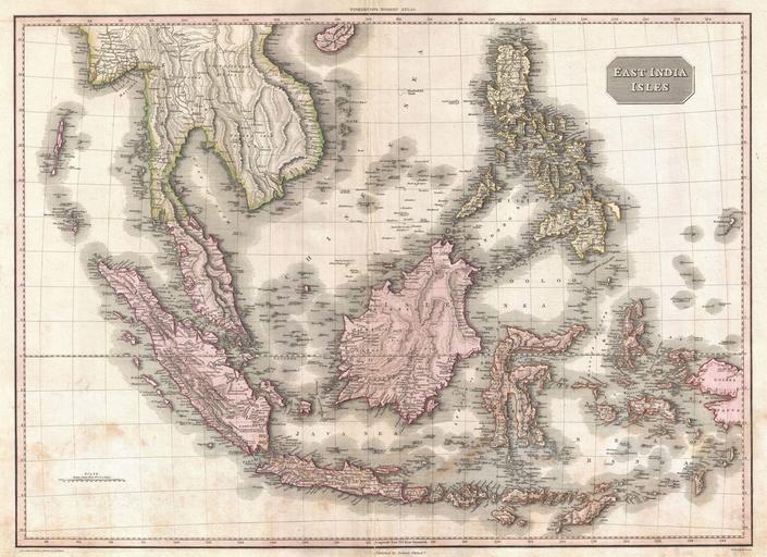
| Keywords: 1818 Pinkerton Map of the East Indies and Southeast Asia (Singapore, Borneo, Java, Sumatra, Thailand - Geographicus - EastIndiaIslands-pinkerton-1818.jpg Truly a masterwork of copperplate engraving this is Pinkerton's extraordinary 1818 map of the East Indies Covers from Burma south to Java and from the Andaman Islands eastward as far as the Philippines and New Guinea Includes the entire Malay Peninsula much of Southeast Asia Thailand Cambodia Vietnam Sumatra Java Borneo and the Philippines Pinkerton offers impressive detail throughout noting indigenous groups forts towns and cities swamps mountains and river systems Known regions such as Java and Sumatra are full of interesting notes and commentary such as the sites of various gold mines plantations notes on river navigation and comments on the terrain Lesser known areas such as New Guinea and the interior of Borneo often feature simpler comments suchas Fresh Water or Lava The island of Singapore spelled Sincapoor is identified The island of Rakata spelled Rakama where Krakatoa famously erupted in 1883 destroying the island in its entirety is also identified Further identifies the important centers of Siam Bangkok Malacca Pegu Rangoon Manila etc Possibly the finest mapping of the region to appear in the 19th century Drawn by L Herbert and engraved by Samuel Neele under the direction of John Pinkerton This map comes from the scarce American edition of Pinkerton ôs Modern Atlas published by Thomas Dobson Co of Philadelphia in 1818 1818 undated Size in 27 5 20 5 object history credit line accession number EastIndiaIslands-pinkerton-1818 Pinkerton J <i>A Modern Atlas from the Lates and Best Authorities Exhibiting the Various Divisions of the World with its chief Empires Kingdoms and States; in Sixty Maps carefully reduced from the Larges and Most Authentic Sources </i> 1818 Philadelphia Thomas Dobson Edition Geographicus-source PD-old-100 Maps by John Pinkerton Old maps of Southeast Asia 1818 maps | ||||