MAKE A MEME
View Large Image
| View Original: | 1823_Darton_and_Gardner_Comparative_Chart_of_World_Mountains_and_Rivers_-_Geographicus_-_MountainsandRivers-darton-1823.jpg (3500x2790) | |||
| Download: | Original | Medium | Small | Thumb |
| Courtesy of: | commons.wikimedia.org | More Like This | ||
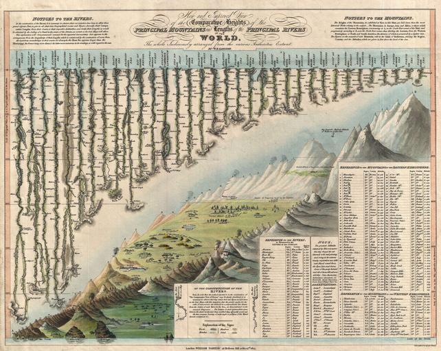
| Keywords: 1823 Darton and Gardner Comparative Chart of World Mountains and Rivers - Geographicus - MountainsandRivers-darton-1823.jpg A groundbreaking convention establishing map of extreme scarcity this is William Darton and W R Gardner ™s 1823 comparative mountains and rivers of the world chart According to Rumsey this is the first known example of a comparative chart to depict both mountains and rivers in the same plate “ thus defining a cartographic style that would flourish throughout the remainder of the 19th century The comparative mountains section occupying the lower right half of this chart details the principle mountains of the world Ranges are color coded to show different types of vegetation and numerically reference tables in the lower right quadrant The elevations of a number of important cities including Paris Rome London Geneva Mexico Bogota and Quito among others are noted There are also extensive notations on vegetation volcanic activity and lichen much of which is no doubt influenced by Humboldt The Himalayan peak Dhaulagiri is identified as the world's greatest mountain Even the ballooning feat of Gay-Lussac who attained an altitude of 7000 meters in 1808 is noted The upper left portion of this chart is dominated by the world's greatest rivers Darton and Gardner attempt not only to express the lengths of the various rivers but also details regarding their course and sources All along each river important lakes cities directions and distance measurements are noted Here the Amazon is identified as the world's greatest river at some 3600 miles followed by the Mississippi at 3530 miles The Nile comes up a sad fifth at just 2686 miles though admittedly its full length had yet to be explored This map is extremely scarce It was issued and sold independently by Darton at his Map and Print Shop 58 Holborn Hill London Examples of this map were issued in both case as in the Rumsey example and flat as in this example format; however it was never included in an atlas or compiled publication This is only the second known example Rumsey ™s being the first to appear either on the market or in an institutional collection That Wolter whose study of Comparative charts is the most significant scholarly approach to this material currently published was not aware of this map is suggestive of its extreme rarity A unique example that will not likely appear on the market again 1823 dated Size in 14 5 11 5 object history credit line accession number MountainsandRivers-darton-1823 Geographicus-source PD-Art-100 Diagrams of mountains 1823 maps Geographic comparison diagrams William Darton Jr William R Gardner River-related diagrams | ||||