MAKE A MEME
View Large Image
| View Original: | 1847_Levasseur_Map_of_Africa_-_Geographicus_-_Africa-levasseur-1847.jpg (4000x2886) | |||
| Download: | Original | Medium | Small | Thumb |
| Courtesy of: | commons.wikimedia.org | More Like This | ||
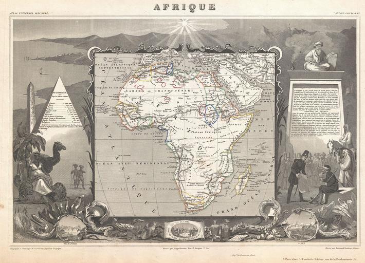
| Keywords: 1847 Levasseur Map of Africa - Geographicus - Africa-levasseur-1847.jpg A stunning c 1847 map of Africa by French cartographer Victor Levasseur Depicts the entire continent with several interesting elements A large lake appears in Mozambique which can only be Lake Malawi Lake Nyasa Lake Chad Tchad is also shown Names numerous African kingdoms including Monomotapa and the Hottentots Surrounded by the elaborate borders for which Levasseur is best known Shows a stylized pyramid and obelisk an imam a French soldier consulting with Arabs and three city vies Alexandria Cairo and Algiers Prepared and published for V Levasseur's magnificent c 1847 Atlas Universel Illustre one of the last decorative atlases of the 19th century circa 1847 undated Size in 18 12 5 object history credit line accession number Africa-levasseur-1847 Levasseur V Atlas Universel Illustre c 1847 Geographicus-source PD-old-100 Victor Levasseur - Maps of the world 1840s maps of Africa 1847 maps History of Alexandria Cairo in art Historical images of Algiers Orientalist paintings in France Algiers in the 1840s | ||||