MAKE A MEME
View Large Image
| View Original: | 1852_S.D.U.K._Pocket_Map_of_the_Balkans,_Croatia,_Dalmatia,_Sclavonia_-_Geographicus_-_AustrianDominionsIII-Knight-1852.jpg (3000x2100) | |||
| Download: | Original | Medium | Small | Thumb |
| Courtesy of: | commons.wikimedia.org | More Like This | ||
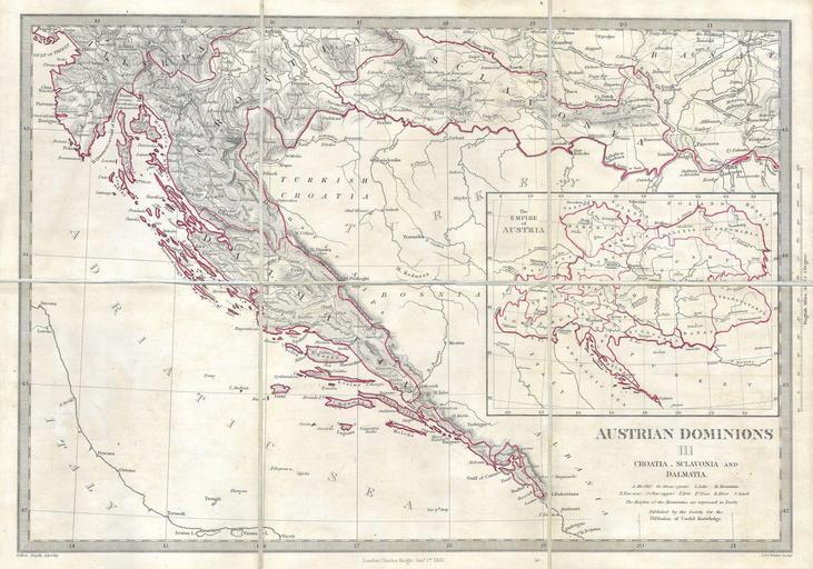
| Keywords: 1852 S.D.U.K. Pocket Map of the Balkans, Croatia, Dalmatia, Sclavonia - Geographicus - AustrianDominionsIII-Knight-1852.jpg This is a S D U K map of a rarely depicted portion of Europe including most of modern day Croatia Depicts the south part of the Austrian Empire including Dalmatia Croatia and Sclavonia A large inset shows the full extent of the Austrian empire This is an unusual issue of an unusual map as it has been broken into pocket map format six sheets and backed with linen This map was probably for inclusion in a library collection Engraved by Weller for the Society for the Diffusion of Useful Knowledge under the Supervision of Charles Knight dated Jan 1 1852 1852 Size in 16 11 object history credit line accession number AustrianDominionsIII-Knight-1852 Geographicus-source PD-art Old maps of Slavonia Maps of the Croatia-Slavonia Maps of the history of Dalmatia Old maps of Croatia 1852 maps Old maps of Serbia Old maps of Vojvodina Old maps of Bosnia and Herzegovina | ||||