MAKE A MEME
View Large Image
| View Original: | 1855_Colton_Map_of_Upper_Canada_or_Ontario_-_Geographicus_-_Ontario-colton-1855.jpg (4000x3286) | |||
| Download: | Original | Medium | Small | Thumb |
| Courtesy of: | commons.wikimedia.org | More Like This | ||
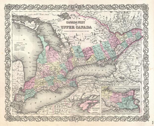
| Keywords: 1855 Colton Map of Upper Canada or Ontario - Geographicus - Ontario-colton-1855.jpg An excellent first edition example of Colton's rare 1855 map of Ontario Covers what at the time was called Upper or West Canada from Michigan to Montreal Includes Lake Erie Lake Ontario and part of Lake Huron Two insets in the lower right quadrant detail Wolf Island and the Welland Canal Throughout the map Colton identifies various cities towns forts rivers rapids fords and an assortment of additional topographical details Map is hand colored in pink green yellow and blue pastels to define national and regional boundaries Surrounded by Colton's typical spiral motif border Dated and copyrighted to J H Colton 1855 Published as page no 6 in volume 1 of the first edition of George Washington Colton's 1855 Atlas of the World 1855 dated Size in 16 13 object history credit line accession number Ontario-colton-1855 Colton G W <i>Colton's Atlas of the World Illustrating Physical and Political Geography</i> Vol 1 New York 1855 First Edition Geographicus-source PD-old-100 Maps by Joseph Hutchins Colton Historic maps of Ontario Second Welland Canal 1855 maps of Canada | ||||