MAKE A MEME
View Large Image

| View Original: | 1858_Smith_and_Chase_Wall_Map_of_Suffolk_Couty,_Long_Island_-_Geographicus_-_SuffolkCountyLongIsland-pearsall-1858.jpg (2226x1844) | |||
| Download: | Original | Medium | Small | Thumb |
| Courtesy of: | commons.wikimedia.org | More Like This | ||
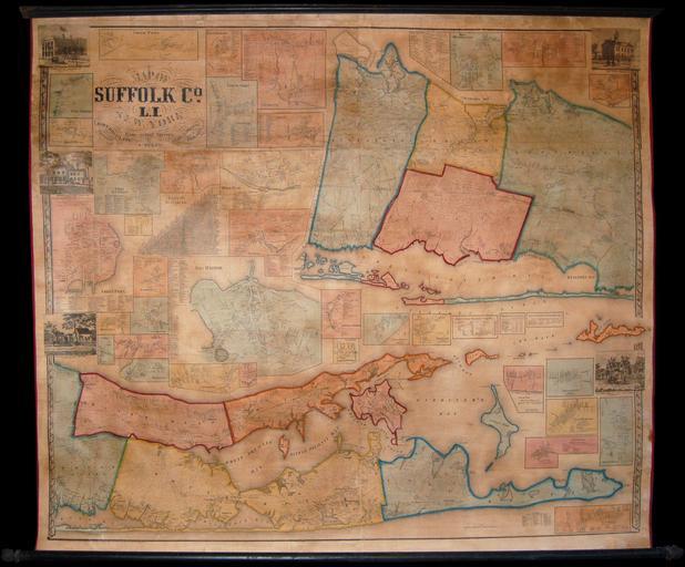
| Keywords: 1858 Smith and Chase Wall Map of Suffolk Couty, Long Island - Geographicus - SuffolkCountyLongIsland-pearsall-1858.jpg Without a doubt one of the finest wall maps of Suffolk County eastern Long Island New York ever made This monumental 1858 wall map covers the eastern part of Long Island roughly from Huntington to Montauk Divided into two main sections upper and lower The upper segment mostly confined to the upper right quadrant focuses on Huntington Smithtown Islip and Brookhaven including most of Fire Island and Oak Island The lower section and the primary focus of the map as a whole covers the eastern extension of Long Island including both forks Brookhaven Riverhead Southampton Southold and East Hampton as well as Gardiners Island and Shelter Island The upper left quadrants of the map as well as any empty zones in other sections are dedicated to detailed town plans These include Cold Spring Amityville Smith town East Setauket Patchogue North Port Babylon Riverhead Penataquit Port Jefferson Greenport Sag Harbor Southold Bridgehampton East Moriches Millers Place Comac West Huntington Bellport Center Moriches Mattituck Aquebogue Jamesport New Suffolk Stony Brook East Marion Orient South Port Amagansett East Hampton Sayville Southampton and Cutchoge The detail throughout is extraordinary with Chase's survey work being by far the most accurate and in depth study of the region undertaken in the first half of the 19th century Chase notes roads farms bridges and the individual family names of various properties In addition to noting property owners and important households chase also includes business directories for the largest and most important towns There are additionally five engraved views including the Wyanbank House of Jeremiah Terry in Greenport the residence of Stephen Haynes of Scuttle Hole the Farmhouse of Elisha King of Good Ground the Riverhead Courthouse and the Summer Residence of C W and J T Moore of Aquebogue The surveys for this map are the work of J Chase Junior The map was a joint publishing venture by Robert Pearsall Smith and John Douglass whose adjacent offices were located at 517 519 and 521 Minor Street Philadelphia PA Dated and copyrighted Entered According to Act of Congress in the Year 1858 by Robert Pearsall Smith in the Cleark's Office of the District Court of the Eastern District of Pennsylvania 1858 dated Size in 59 51 object history credit line accession number SuffolkCountyLongIsland-pearsall-1858 Geographicus-source PD-art Old maps of Long Island 1858 Maps of Suffolk County New York 1858 1858 maps 1858 in New York North Fork New York 1858 | ||||