MAKE A MEME
View Large Image
| View Original: | 1859_Colton_Pocket_Map_of_Arkansas_(_Railroads_)_-_Geographicus_-_Arkansas-colton-1859.jpg (5000x4119) | |||
| Download: | Original | Medium | Small | Thumb |
| Courtesy of: | commons.wikimedia.org | More Like This | ||
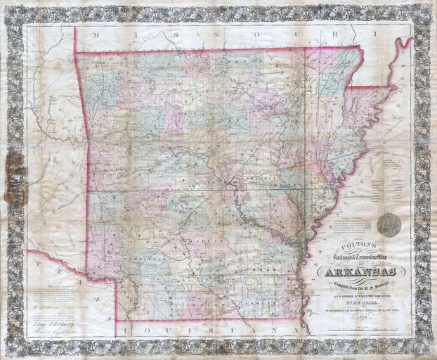
| Keywords: 1859 Colton Pocket Map of Arkansas ( Railroads ) - Geographicus - Arkansas-colton-1859.jpg This large and visually stunning 1858 pocket map by J H Colton depicts the state of Arkansas The state of Arkansas is revealed in considerable detail with special attention to roads railroads rivers lakes and towns The state is cleanly divided into various counties To the east Texas asppears as do the Indian territories of the Choctaws and the Cherokees The state seal of Arkansas is depicted in the lower right quadrant just above the title Fine decorative border Dated and copyrighted Entered according to the Act of Congress in the Year of 1854 by J H Colton Co in the Clerk ™s Office of the District Court of the United States for the Southern District of New York Published from Colton ™s 172 William Str Office in New York City Exceedingly rare 1859 Size in 26 31 object history credit line accession number Arkansas-colton-1859 Geographicus-source PD-old-100 Maps by Joseph Hutchins Colton Old maps of Arkansas 1859 maps | ||||
_-_Geographicus_-_Arkansas-colton-1859.jpg)