MAKE A MEME
View Large Image
| View Original: | 1900_U.S._Geological_Survey_of_Boston_and_Vicinity,_Massachusetts_-_Geographicus_-_Boston-USGS-1900.jpg (3013x4000) | |||
| Download: | Original | Medium | Small | Thumb |
| Courtesy of: | commons.wikimedia.org | More Like This | ||
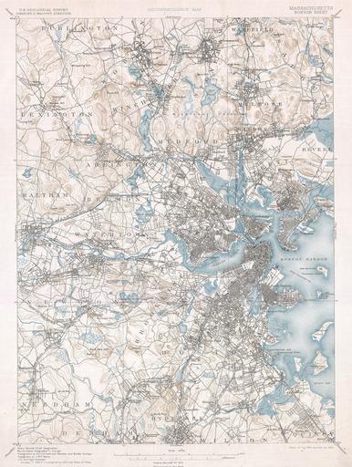
| Keywords: 1900 U.S. Geological Survey of Boston and Vicinity, Massachusetts - Geographicus - Boston-USGS-1900.jpg One of the most sought after topographical maps produced by the U S Geological Survey The 1900 edition of the U S G S Survey Map of Boston and vicinity covers from Burlington to Dedham and from Waltham to Boston Harbor Offers extraordinary detail to the level of streets and often individual buildings Includes Boston area communities of Boston Summerville Brookline Chelsea Cambridge Newton Watertown Belmont Waltham Medford Everett Revere South Boston Quincy Hyde Park Needham Malden Identifies Harvard College and Tufts College as well as numerous other points of interest Prepared by Henry Gannett E W F Natter J H Jennings and Marcus Baker in 1887 1900 dated Size in 14 19 5 object history credit line accession number Boston-USGS-1900 Geographicus-source PD-art United States Geological Survey maps Old maps of Boston 1900 maps | ||||