MAKE A MEME
View Large Image

| View Original: | Alexishafen,_Astrolabe_Bay,_1883.jpg (1882x2141) | |||
| Download: | Original | Medium | Small | Thumb |
| Courtesy of: | commons.wikimedia.org | More Like This | ||
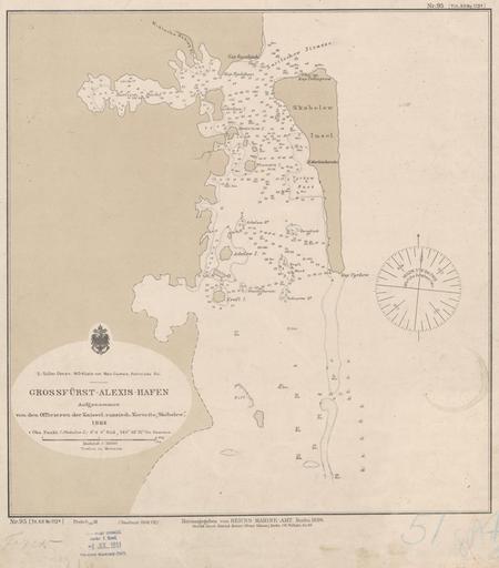
| Keywords: Alexishafen, Astrolabe Bay, 1883.jpg Nautical map of Astrolabe Bay near Alexishafen named by Nicholas Mikhlouho-Maclay after the Admiral of the Imperial Russian Navy Alexei Alexandrovich Romanov in Papua New Guinea with depth shown by soundings The map was made during the visit of the Imperial Russian corvette Skobolew in 1883 At the top of the map can be seen the Miklucha Maklay Fluss Mikhlouho-Maclay River This version of the map was published in Germany in 1908 Alexis-Hafen cartographic material ausgenommen von den Offizieren der Kaiserlich russischen Korvette ┬½Skobelew┬╗ 1883 uk ąōč¢ą┤č ąŠą│č ą░čäč¢čćąĮą░ ą╝ą░ą┐ą░ ąĘ ąĘą░ąĘąĮą░č湥ąĮąĮčÅą╝ ą│ą╗ąĖą▒ąĖąĮ ą▓ ąĘą░č鹊čåč¢ ąÉčüčéč ąŠą╗čÅą▒č¢čÅ ą▒č¢ą╗čÅ ąÉą╗ąĄą║čüč¢čüą│ą░č乥ąĮ Alexishafen ą¤ąŠč čé ą×ą╗ąĄą║čüč¢ą╣ čüą║ą╗ą░ą┤ąĄąĮą░ ą┐č¢ą┤ čćą░čü ą┐ąĄč ąĄą▒čāą▓ą░ąĮąĮčÅ č¢ą╝ą┐ąĄč ą░č鹊č čüčīą║ąŠą│ąŠ č ąŠčüč¢ą╣čüčīą║ąŠą│ąŠ ą║ąŠč ą▓ąĄčéą░ ┬½ąĪą║ąŠą▒ąĄą╗ąĄą▓┬╗ 1883 č č¢ą║ 1908 http //nla gov au/nla map-rm3894 National Library of Australia author -5 0833 145 8 Custom license marker 2013 07 17 PD-old Uploaded with UploadWizard Bays of Papua New Guinea Maps of Papua New Guinea | ||||