MAKE A MEME
View Large Image
| View Original: | AMH-4721-NA_Map_of_Fort_Nassau_on_Banda_Neira.jpg (2400x1898) | |||
| Download: | Original | Medium | Small | Thumb |
| Courtesy of: | commons.wikimedia.org | More Like This | ||
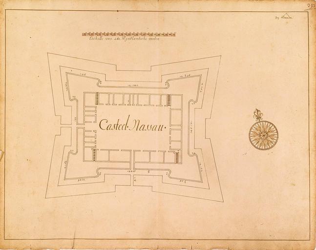
| Keywords: AMH-4721-NA Map of Fort Nassau on Banda Neira.jpg Artwork nl Plattegrond van fort Nassau op Banda Neira nl Titel catalogus Leupe NA Plan van 't Casteel Nassau Behoort bij het rapport van Arnold de Vlamingh van Outshoorn Rechts boven genummerd 393 Notities verso 393 moet het folionummer in de band OBP zijn / 664 f en According to the Leupe catalogue NA the original title reads Plan van 't Casteel Nassau Belongs with the report of Arnold de Vlamingh van Outshoorn Numbered top right 393 Notes on reverse 393 must refer to the folio number in the OBP volume / 664 f Atlas of Mutual Heritage na http //www atlasofmutualheritage nl/en/object/ id 4721 Source at the Atlas of Mutual Heritage - http //www gahetna nl/collectie/archief/inventaris/index/eadid/4 VEL/inventarisnr/1358/level/file Source at the Nationaal Archief en Subjects fortification chart / map / plan compass / dial nl Onderwerpen vesting plattegrond / kaart kompas / windroos en Fort this image is related to a VOC fort called http //www atlasofmutualheritage nl/en/fort/ id 14 fort Neira Nassouw Inscription Casteel Nassau nl circa 1651 nl Anoniem / Anonymous en Anoniem / Anonymous Institution Nationaal Archief nl pen op papier en pen on paper Size cm 33 41 5 accession number NL-HaNA_4 VEL_1358 old number VEL1358 PD-Art-100 Maps of the Dutch East India Company - Indonesia 1651 Fort Nassau Banda Islands | ||||