MAKE A MEME
View Large Image
| View Original: | AMH-5652-KB Map of the African continent.jpg (2400x1948) | |||
| Download: | Original | Medium | Small | Thumb |
| Courtesy of: | commons.wikimedia.org | More Like This | ||
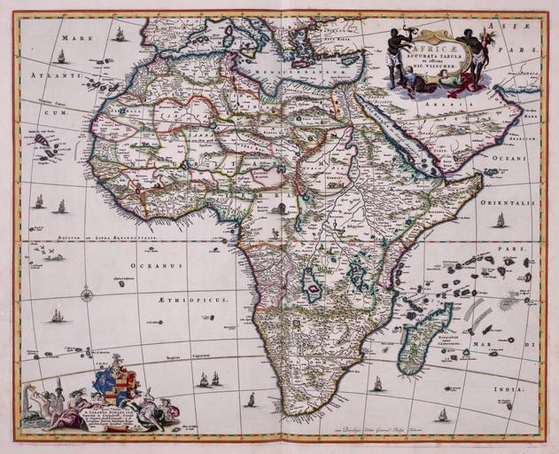
| Keywords: AMH-5652-KB Map of the African continent.jpg Artwork nl Kaart van het continent Afrika nl Kaart van het continent Afrika uit de Atlas van der Hagen Koninklijke Bibliotheek Den Haag Deel 4 Afgezien van de kustlijnen is deze kaart van Afrika nauwelijks betrouwbaar Dat is niet alleen kenmerkend voor deze kaart van Nicolaas Visscher II 1649-1702 maar dat geldt voor de meeste kaarten van Afrika die tijdens de 17de en 18de eeuw werden gepubliceerd Pas in de tweede helft van de 19de eeuw werden de Afrikaanse binnenlanden beetje voor beetje opengelegd en Map of the continent of Africa taken from the Atlas van der Hagen Koninklijke Bibliotheek The Hague Part 4 This map of Africa is highly inaccurate except for the coastline This is characteristic of most of the maps of Africa published during the 17th and 18th centuries and not only of this chart made by Nicolaas Visscher II 1649-1702 It was only in the latter half of the 19th century that the African hinterland gradually unlocked its secrets Atlas of Mutual Heritage kb http //www atlasofmutualheritage nl/en/object/ id 5652 Source at the Atlas of Mutual Heritage en Subjects ship / vessel compass / dial Asians Africans chart / map / plan banderole / cartouche / ornamentation Person nl Onderwerpen schip / vaartuig kompas / windroos Aziaten Afrikanen plattegrond / kaart banderol / cartouche / versiering Persoon Inscription AFRICAE ACCURATA TABULA author ex officina Nic Visscher nl between 1681 1702 Creator Nicolaas Visscher II nl Nicolaas Visscher II uitgever en Nicolaas Visscher II publisher Institution Koninklijke Bibliotheek nl koperdruk op papier en copperplate printing on paper Size cm 44 56 accession number 1049B13_057 PD-Art-100 Old maps of the Dutch East India Company - Africa | ||||