MAKE A MEME
View Large Image
| View Original: | AMH-6044-NA_Map_of_farmlands_in_the_Batavia_area,_part_nine.jpg (2400x1481) | |||
| Download: | Original | Medium | Small | Thumb |
| Courtesy of: | commons.wikimedia.org | More Like This | ||
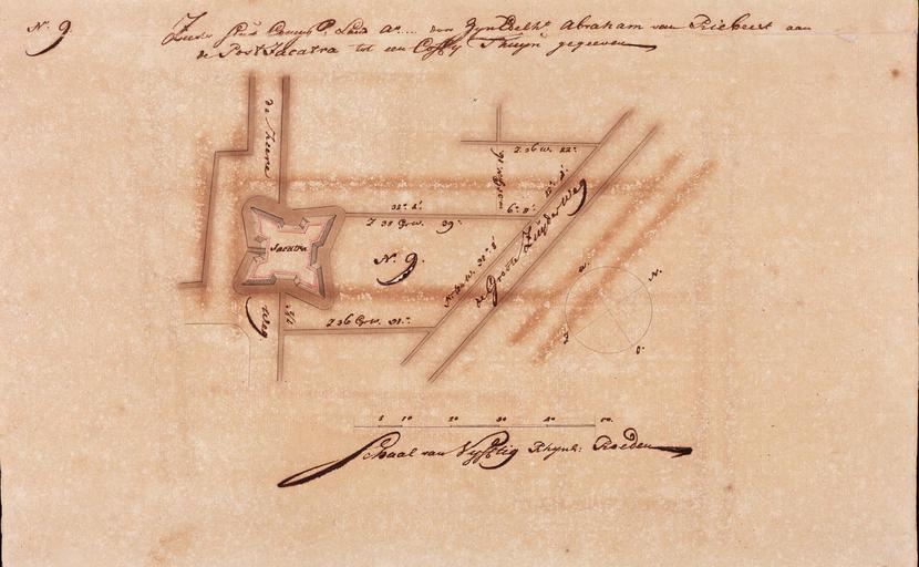
| Keywords: AMH-6044-NA Map of farmlands in the Batavia area, part nine.jpg Artwork nl Kaart van landerijen in de omgeving van Batavia deel negen nl Titel catalogus Leupe NA Zeeker stuk Compagnie's land a door Z E Abraham van Riebeek aan den post Jacatra tot een coffijthuijn gegeeven Het kaartje maakt deel uit van een verzameling van 24 kaartjes en is genummerd no 9 linksboven en in het midden N 9 De nummers 11 20 21 en 26 ontbreken Rechtsonder een kompas Z;W;N;O en schaalverdeling Schaal van Vijftig Rhijns Roeden In het midden een plattegrond van wegen grachten en fort zoals de Groote Zuyder weg de heere weg Jacatra en Title in the Leupe catalogue NA Zeeker stuk Compagnie's land a door Z E Abraham van Riebeek aan den post Jacatra tot een coffijthuijn gegeeven The map is part of a collection of 24 charts and is numbered no 9 top left and in the centre N 9 The numbers 11 20 21 and 26 are missing Bottom right a compass Z;W;N;O and a scale Schaal van Vijftig Rhijns Roeden In the centre a map of roads canals and a fort comprising de Groote Zuyder weg de heere weg Jacatra Atlas of Mutual Heritage na http //www atlasofmutualheritage nl/en/object/ id 6044 Source at the Atlas of Mutual Heritage - http //www gahetna nl/collectie/archief/inventaris/index/eadid/4 VELH/inventarisnr/452 9/level/file Source at the Nationaal Archief en Subjects compass / dial building fortification estate / plantation chart / map / plan nl Onderwerpen kompas / windroos gebouw vesting landerij / plantage plattegrond / kaart en Fort this image is related to a VOC fort called http //www atlasofmutualheritage nl/en/fort/ id 46 fort Jacatra Inscription Zeeker Stuk Comp Land A door Zijn Edelht Abraham van Riebeek aan de Post Jacatra tot een Coffy Thuijn gegeeven nl between 1689 1709 nl Anoniem / Anonymous en Anoniem / Anonymous Institution Nationaal Archief nl pen en penseel op papier en pen and brush on paper Size cm 26 5 42 5 accession number NL-HaNA_4 VELH_452 9 old number VELH0452_9 PD-Art-100 Fort Jacatra Maps of the Dutch East India Company - Indonesia Indonesia in the 17th century | ||||