MAKE A MEME
View Large Image
| View Original: | AMH-8090-KB_Map_of_the_island_of_St._Louis_in_the_Sanaga_River_and_a_floor_plan_and_map_of_the_St._Joseph_fort.jpg (1724x2400) | |||
| Download: | Original | Medium | Small | Thumb |
| Courtesy of: | commons.wikimedia.org | More Like This | ||
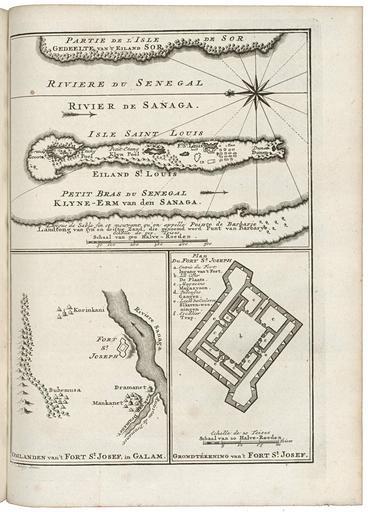
| Keywords: AMH-8090-KB Map of the island of St. Louis in the Sanaga River and a floor plan and map of the St. Joseph fort.jpg Artwork nl Kaart van het eiland St Louis in de rivier Sanaga en een plattegrond en kaart van het fort St Joseph nl Kaart van het eiland St Louis in de rivier Sanaga en een plattegrond en kaart van het fort St Joseph Omlanden van 't Fort St Josef in Galam / Grondtékening van 't Fort st Josef Legenda a-f en Map of the island of St Louis in the Sanaga River and a floor plan and chart of the St Joseph fort Omlanden van 't Fort St Josef in Galam / Grondtékening van 't Fort st Josef Key a-f Atlas of Mutual Heritage kb http //www atlasofmutualheritage nl/en/object/ id 8090 Source at the Atlas of Mutual Heritage en Subjects chart / map / plan key fortification compass / dial nl Onderwerpen plattegrond / kaart legenda vesting kompas / windroos en Post this image is related to a WIC trading post called http //www atlasofmutualheritage nl/en/post/ id 1904 St Louis Inscription Omlanden van 't Fort St Josef in Galam / Grondtékening van 't Fort st Josef author J v Schley direx nl 1750 Creator Jacobus van der Schley Creator Pierre d' Hondt nl Jacobus van der Schley direxit Pierre d' Hondt uitgever en Jacobus van der Schley direxit Pierre d' Hondt publisher Institution Koninklijke Bibliotheek nl gravure op papier en engraving on paper Size cm 26 19 accession number 693 C 6 dl III to p 298 PD-Art-100 1750 | ||||