MAKE A MEME
View Large Image
| View Original: | AMH-8165-KB_Map_of_the_Senegal_River.jpg (1809x2400) | |||
| Download: | Original | Medium | Small | Thumb |
| Courtesy of: | commons.wikimedia.org | More Like This | ||
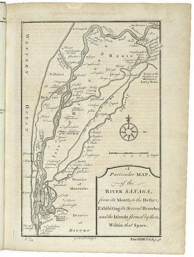
| Keywords: AMH-8165-KB Map of the Senegal River.jpg Artwork nl Kaart van de rivier Senegal nl Kaart van de rivier Senegal A Particular Map of the River Sanaga from its Mouth to the Desart; Exhibiting its Several Branches and the Islands formed by them Within that Space Rechtsonder Plate XXXIII Vol II p 48 Linksonder No 52 en Map of the Senegal River A Particular Map of the River Sanaga from its Mouth to the Desart; Exhibiting its Several Branches and the Islands formed by them Within that Space Bottom right Plate XXXIII Vol II p 48 Bottom left No 52 Atlas of Mutual Heritage kb http //www atlasofmutualheritage nl/en/object/ id 8165 Source at the Atlas of Mutual Heritage en Subjects chart / map / plan compass / dial banderole / cartouche / ornamentation nl Onderwerpen plattegrond / kaart kompas / windroos banderol / cartouche / versiering en Post this image is related to a WIC trading post called http //www atlasofmutualheritage nl/en/post/ id 1904 St Louis Inscription A Particular Map of the River Sanaga from its Mouth to the Desart; Exhibiting its Several Branches and the Islands formed by them Within that Space author G Child Sculpt nl 1745 Creator G Child nl G Child graveur / etser Anoniem / Anonymous uitgever en G Child engraver / etcher Anoniem / Anonymous publisher Institution Koninklijke Bibliotheek nl gravure op papier en engraving on paper Size cm 18 5 14 accession number 3032 B 10 to p 48 PD-Art-100 Maps of the West-Indische Compagnie 1745 | ||||