MAKE A MEME
View Large Image

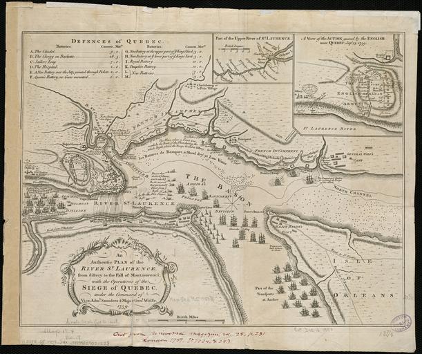
| View Original: | An_authentic_plan_of_the_River_St._Laurence,_from_Sillery_to_the_Fall_of_Montmorenci,_with_the_operations_of_the_Siege_of_Quebec,_under_the_command_of_Vice-Adml._Saunders_&_Major_Genl._Wolfe_(4231927448).jpg (2000x1676) | |||
| Download: | Original | Medium | Small | Thumb |
| Courtesy of: | commons.wikimedia.org | More Like This | ||
| Keywords: An authentic plan of the River St. Laurence, from Sillery to the Fall of Montmorenci, with the operations of the Siege of Quebec, under the command of Vice-Adml. Saunders & Major Genl. Wolfe (4231927448).jpg An authentic plan of the River St Laurence from Sillery to the Fall of Montmorenci with the operations of the Siege of Quebec under the command of Vice-Adml Saunders Major Genl Wolfe Location Québec Quebec Saint Lawrence River Cut from Universal Magazine vol 25 p 281 London 1759 Dimension 27x36cm Scale ca 1 35 000 Call Number G3312 S5 1759 J4x http //www flickr com/photos/normanbleventhalmapcenter/4231927448/ An authentic plan of the River St Laurence from Sillery to the Fall of Montmorenci with the operations of the Siege of Quebec under the command of Vice-Adml Saunders Major Genl Wolfe Map reproduction from the Norman B Leventhal Map Center at the Boston Public Library Uploaded to Wikimedia Commons by tm Map 1759<br /> Photographic reproduction 2009-12-30 14 47 Map Creator Thomas Jefferys Photographic reproduction http //www flickr com/people/24528911 N05 http //maps bpl org Zoom into http //maps bpl org/id/14101 this map at http //maps bpl org maps bpl org PD-old-100-1923 cc-by-2 0 File Upload Bot Magnus Manske 2013-08-21 1759 maps of Canada Maps of Quebec City Maps of the Battle of the Plains of Abraham Old maps of Quebec Old maps of the Saint Lawrence River Thomas Jefferys Photos from Norman B Leventhal Map Center at the BPL's photostream | ||||