MAKE A MEME
View Large Image

| View Original: | B15a_figure3b.jpg (1254x950) | |||
| Download: | Original | Medium | Small | Thumb |
| Courtesy of: | commons.wikimedia.org | More Like This | ||
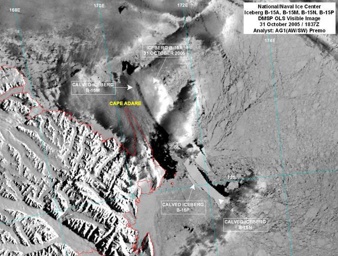
| Keywords: B15a figure3b.jpg en An iceberg about the size of the Hawaiian island of Maui has split into three pieces in the frigid Antarctic waters the National Ice Center reported this week Using satellite imagery from the Defense Meteorological Satellite Program the NIC discovered that the larger iceberg named B-15A calved into three smaller icebergs B-15M B-15N and B-15P Two of the larger icebergs B-15M and B-15N are about the size of Grand Cayman and St Croix respectively 2005-10-31 http //www noaanews noaa gov/stories2005/s2530 htm NOAA/Defense Meteorological Satellite Program PD-USGov-NOAA PD-USGov-Military-Navy Original upload log 1 date/time username edit summary ---- 00 31 8 December 2005 en User Peter Ellis <nowiki> <span class autocomment ><a href /wiki/Image B15a_figure3b jpg Summary title Image B15a figure3b jpg > †’</a>Summary</span> </nowiki> ---- 00 30 8 December 2005 en User Peter Ellis <nowiki> US <a href /wiki/NOAA title NOAA >NOAA</a> image of <a href /wiki/Iceberg_B-15 title Iceberg B-15 >Iceberg B-15</a> break-up with analysis and overlays <a href /wiki/31_October title 31 October >31 October</a> <a href /wiki/2005 title 2005 >2005</a> Base image from <a href /wiki/Defense_Meteorological_Satellite_Program title Defense Meteorological Satellite Program >Defense Meteorological Satellite Program</a> DMSP </nowiki> Legend cur this is the current file del delete this old version rev revert to this old version Click on date to download the file or see the image uploaded on that date del cur 00 30 8 December 2005 en User Peter_Ellis Peter Ellis en User_talk Peter_Ellis Talk 700x530 112555 bytes US en NOAA NOAA image of en Iceberg_B-15 Iceberg B-15 break-up with analysis and overlays en 31_October 31 October en 2005 2005 Base image from en Defense_Meteorological_Satellite_Program Defense Meteorological Satellite Program DMSP Iceberg B-15 Defense Meteorological Satellite Program Satellite pictures of icebergs Maps of icebergs | ||||