MAKE A MEME
View Large Image

| View Original: | Battle_of_Mobile_Bay_map.jpg (560x800) | |||
| Download: | Original | Medium | Small | Thumb |
| Courtesy of: | commons.wikimedia.org | More Like This | ||
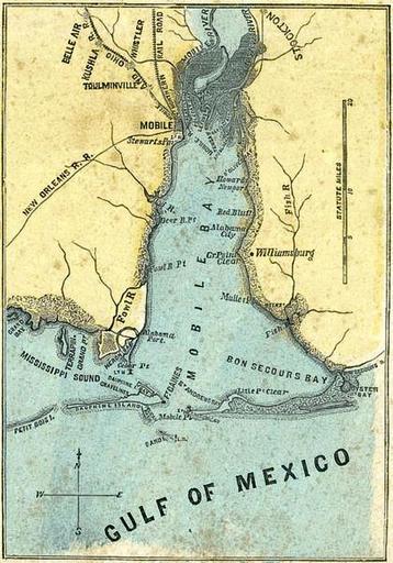
| Keywords: Battle of Mobile Bay map.jpg Short Title H H Lloyd Co's Campaign Military Charts Showing The Principal Strategic Places Of Interest map of w Mobile Bay Date 1861 Author Lloyd H H ; Viele Egbert L ; Haskins Charles <br> Publisher New York H H Lloyd Co Format File is in JPEG format 10x-20x times faster than Portable Network Graphics PNG -format files due to auto-resizing as a smaller file 10-Feb-07 Full Title H H Lloyd Co's Campaign Military Charts Showing The Principal Strategic Places Of Interest Engraved Expressly To Meet A Public Want During The Present War Compiled From Official Data By Egbert L Viele Military and Civil Engineer; and Charles Haskins Published Under The Auspices Of The American Geographical And Statistical Society Entered 1861 by H H Lloyd Co H H Lloyd Co's Military Charts Sixteen Maps On One Sheet Source http //www davidrumsey com Variations Portable Network Graphics PNG -format file same width 420x600 10x larger file Image Battle of Mobile Bay map png 587 kilobyte KB Map labels clockwise from top Northern bay Mobile River Tensaw River Appalacha River D'Olive's Bay Batteau Bay Tensaw R Levons B Polecat Bay Blakely I Mobile River Mobile R ; Eastern shore Stockton AL Stockton D'Olive's Bay Howards Newport Fish River Red Bluffs Alabama City Williamsburg Point Clear AL GrPoint Clear Mullet Point Weeks' Bay Fish River Fish R Bon Secour s R iver ; Bottom bay Oyster Bay Bon Secour s Bay Litle Pt Clear St Andrews Bay L<sup>T</sup> H Fort Morgan Ft Morgan Mobile Pt Sand I sland / L H Fort Gaines F<sup>T</sup> Gaines Pelican Bay Dauphin Island Dauphine I Bay Gravelines Dauphin Island Dauphine Island Petit Bois Island Petit Bois I sland MISSISSIPPI SOUND; Western shore Grand Bay AL Grand Bay Terrapin Grand Pt Heron Bay L<sup>T</sup> H Cedar Pt Alabama Port Fowl River Fowl R iver Fowl R Pt Deer R iver Pt Dog R iver New Orleans R R railroad Stewarts Pav L<sup>T</sup> H Mobile AL MOBILE Mobile and Ohio R R railroad Gt Northern Rail Road Toulminville Whistler AL Whistler Kushla Belair AL Belle Air Transferred from http //en wikipedia org en wikipedia to Commons by User Undead_warrior using http //tools wikimedia de/~magnus/commonshelper php CommonsHelper 100px PD-old Original upload log en wikipedia Battle_of_Mobile_Bay_map jpg 2007-02-10 18 18 Wikid77 420×600× 61245 bytes <nowiki>Short Title H H Lloyd Co's Campaign Military Charts Showing The Principal Strategic Places Of Interest map of Mobile Bay Author Lloyd H H ; Viele Egbert L ; Haskins Charles Date 1861 Short Title H H Lloyd Co's Campaign Mili</nowiki> Old maps of Mobile Alabama during the American Civil War Mobile Bay Barrier islands of the United States Maps by Egbert Ludovicus Viele | ||||