MAKE A MEME
View Large Image
| View Original: | Carte_statistique_des_ĂŠgouts_-_Nord-Est,_Princeton_University.jpg (4085x3273) | |||
| Download: | Original | Medium | Small | Thumb |
| Courtesy of: | commons.wikimedia.org | More Like This | ||
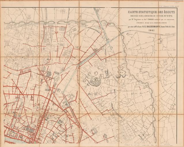
| Keywords: Carte statistique des ĂŠgouts - Nord-Est, Princeton University.jpg en Below Segment Nord-Est 1861 of Haussmann s Carte statistique des ĂŠgouts dressĂŠe sur la demande du conseil municipal par M l ingĂŠnieur en chef Emmery continuĂŠe par ses successeurs ĂŠtendue jusqu aux fortifications par ordre de Mr le Baron G E Haussmann 1861 Paris imp lith de V Janson 1861 Historic Maps Collection Lithograph map in four segments with added color each segment dissected in fifteen pieces mounted on cloth 150 Ă 190 cm <br/> Certainly not the first sewer map of Paris but the largest roughly 5 feet Ă 6 feet and most detailed of its time indicative of the scope and scale of Haussmann s massive undertaking Under his watch the sewer system was quintupled and tunnel sizes were greatly enlarged and standardized Note the outer numbered sections of the fortifications which mark the boundaries of the city proper Lithograph map with added color Size cm 190 150 Institution Princeton University Library object history exhibition history credit line accession number place of creation http //libweb5 princeton edu/visual_materials/maps/websites/thematic-maps/qualitative/qualitative-thematic-maps2 html Quantitative Thematic Maps - Princeton University PD-100 Ăgouts de Paris 1861 Maps of Paris in the 19th century Images from the Princeton University Library Maps of Haussmann's renovation of Paris 1861 in Paris 1861 maps 19th-century maps of Paris | ||||