MAKE A MEME
View Large Image

| View Original: | Dublin_East_&_Ctr_w_Roads_&_Trams_w_Termini_inc_centre_pt_Nelsons_Pillar.jpg (1255x2042) | |||
| Download: | Original | Medium | Small | Thumb |
| Courtesy of: | commons.wikimedia.org | More Like This | ||
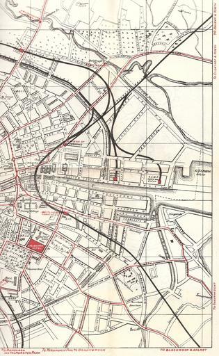
| Keywords: Dublin East & Ctr w Roads & Trams w Termini inc centre pt Nelsons Pillar.jpg Sketch-style map of Dublin Ireland east and centre N and S of R Liffey with land use note green areas key buildings rivers roads railways and also tram lines inc stops and termini inc system central point Nelson's Pillar and power plant Map perhaps E half of a set of 2 apparently from a Guide to Dublin dated on reverse 1912 1912 Unknown publishing house graphic copyright expired in Russia 50 yrs from publication; in EU for unknown author 70 years from publication; in USA all works pre-1923 PD-old Notes The exiting rail and road lines marked for Raheny and Howth are only ordinary road and mainline rail - unlike other exit points there is no tram line though one was originally planned Nelson's Pillar-Fairview-Killester-Raheny-Howth but abandoned in favour of the cheaper-but-longer Dublin-Clontarf-Dollymount-RahenyByTheSea-Sutton-Howth line operated by the Clontarf and Hill of Howth Trams Car32moscow <span class signature-talk >talk</span> 06 47 11 August 2008 UTC Note also the shape of the mouth of the R Tolka the number of main rail stations in the port area and the parkland as well as the prominence of the Shelbourn Hotel Maps of Dublin Public transport maps of Dublin Historic Dublin tram systems | ||||