MAKE A MEME
View Large Image
| View Original: | Ethnic_map_East_Prussia_1907.jpeg (1682x2139) | |||
| Download: | Original | Medium | Small | Thumb |
| Courtesy of: | commons.wikimedia.org | More Like This | ||
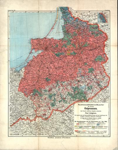
| Keywords: Ethnic map East Prussia 1907.jpeg Nationalitäten-Karte der Provinz Ostpreussen / auf Grund amtlicher Angaben entworfen von Paul Langhans Die Angaben über die Sprachverhältnisse beruhen auf den Feststellungen des Königlich Preußischen Statistischen Landesamtes Die Gemeindeeinheiten nach der Muttersprache am 1 Dez 1900 Nationalities map of the Province of East Prussia / on the basis of official data made by Paul Langhans The data on the languages are based on reports of the Royal Prussian Statistical State Office The municipality units according to their mother tongue on 1 December 1900 http //gauss suub uni-bremen de/suub/hist/index jsp id Kt +I-896 Paul Langhans Gotha Perthes 1907 1907 Lithuania Minor png PD-Art 1907 in Germany Population maps Maps of the East Prussian plebiscite East Prussian plebiscite Old maps of East Prussia Old Linguistic maps 1907 Maps showing history in German Historical maps of ethnic groups in Poland | ||||