MAKE A MEME
View Large Image
| View Original: | GIUK_gap.png (1024x1239) | |||
| Download: | Original | Medium | Small | Thumb |
| Courtesy of: | commons.wikimedia.org | More Like This | ||
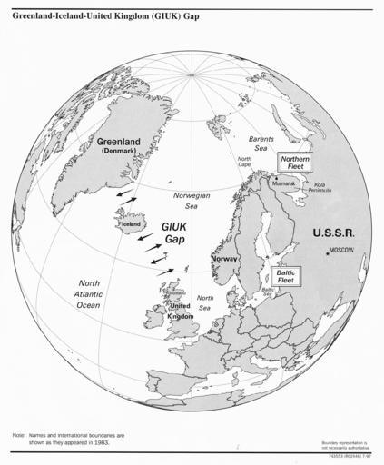
| Keywords: GIUK gap.png This is a PNG version of Guik gap gif as it appeared on the English Wikipedia As it has been recommended that the GIF version is replaced by a PNG or SVG version I converted the original GIF to PNG and uploaded it to Wikimedia Commons instead All I have done is convert the image to PNG and rename it to GIUK_gap instead of Guik gap in correspondance with the Wikipedia article on the GIUK gap https //www cia gov/csi/monograph/coldwar/pg9 gif - - http //en wikipedia org/wiki/Image Guik_gap gif Original GIF summary The GIUK gap is an area in the northern Atlantic Ocean that forms a naval warfare chokepoint Its name is an acronym for Greenland Iceland and the United Kingdom the gap being the open ocean between these three landmasses The term is typically used in military topics source https //www cia gov/csi/monograph/coldwar/pg9 gif PD-USGov Maps of the Atlantic Ocean Physical oceanography Naval graphs maps and schematics Sonar Espionage Maps of the Cold War | ||||