MAKE A MEME
View Large Image
| View Original: | Hispania_in_Harley_MS_3686_-_15th_century.jpg (940x1230) | |||
| Download: | Original | Medium | Small | Thumb |
| Courtesy of: | commons.wikimedia.org | More Like This | ||
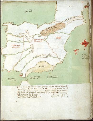
| Keywords: Hispania in Harley MS 3686 - 15th century.jpg es Mapa de la península Ibérica en un atlas manuscrito anónimo del siglo XV escrito en latín Harley MS 3686 de la British Library Tiene la particularidad de mostrar las fronteras entre los reinos ibéricos Portugal Castilla Aragón Navarra y de un color diferente el reino musulmán de Granada circa 1425 1450 http //www bl uk/catalogues/illuminatedmanuscripts/ILLUMIN ASP Size mid IllID 21749 Harley MS 3686 f 15 Anonymous author probably Venetian 15th century other versions PD-old-100 Uploaded with UploadWizard Harley MS 3686 15 Maps made in the 15th century Maps of the history of Spain Maps of the history of Portugal Old maps of the Iberian Peninsula Manuscript maps Maps of the Emirate of Granada Maps of the Kingdom of Castile Maps of the Kingdom of Aragon Maps of the Kingdom of Navarre | ||||