MAKE A MEME
View Large Image
| View Original: | Islam in Netherlands.jpg (1027x1195) | |||
| Download: | Original | Medium | Small | Thumb |
| Courtesy of: | commons.wikimedia.org | More Like This | ||
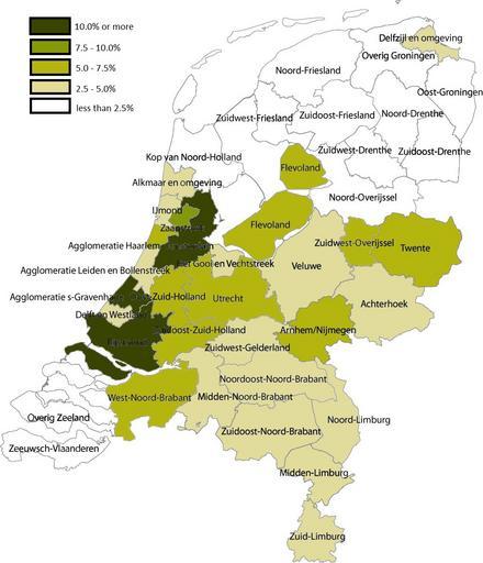
| Keywords: Islam in Netherlands.jpg en Share of Muslims per COROP area 1 January 2004 Data are from Statistics Netherlands http //statline cbs nl/StatWeb/publication/ DM SLNL PA 70794ned D1 3 D2 17-56 D3 0 HDR T STB G1 G2 VW T this Statline table ; note that Statistics Netherlands calculated the number of muslims by adding up all persons by country of 'origin' That method changed in 2006 allowing for a more accurate measuring of actual muslims; see http //www cbs nl/nl-NL/menu/themas/bevolking/publicaties/artikelen/archief/2007/2007-2278-wm htm this CBS webpage Coropgebieden_plain png 2011-01-06 05 02 UTC Coropgebieden_plain png Classical geographer derivative work Giornorosso <span class signature-talk >talk</span> Share of Muslims per COROP area 1 January 2004 Giornorosso Coropgebieden_plain png Cc-zero Original upload log This image is a derivative work of the following images File Coropgebieden_plain png licensed with Cc-zero 2010-07-28T16 31 25Z Classical geographer 1027x1195 213857 Bytes <nowiki>Without border </nowiki> 2010-07-28T16 30 11Z Classical geographer 1102x1300 215966 Bytes <nowiki>B W and with more readable labels </nowiki> 2009-07-09T11 31 36Z Classical geographer 1199x1407 554327 Bytes <nowiki> Maps of the Netherlands Statistical divisions</nowiki> 2009-07-09T11 30 29Z Classical geographer 3588x3529 566115 Bytes <nowiki> en Map of the Dutch NUTS3 regions COROP regions Made using GIS software Own work by uploader Classical geographer 2009-07-09 Permission</nowiki> Uploaded with derivativeFX Maps of provinces of the Netherlands Maps of the Netherlands | ||||