MAKE A MEME
View Large Image
| View Original: | La_Cité_entre_le_Pont_Notre-Dame_et_le_Pont_au_Change_1754.jpg (1792x2630) | |||
| Download: | Original | Medium | Small | Thumb |
| Courtesy of: | commons.wikimedia.org | More Like This | ||
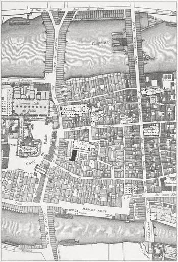
| Keywords: La Cité entre le Pont Notre-Dame et le Pont au Change 1754.jpg Plans of the area between the Pont Notre-Dame and the Pont au Change on the Ile de la Cité On the left a plan from 1754 On the right a plan from 1838 A plan dated 1875 is overlaid on both sides 1875-1882 lithograph 24 x 30 cm Institution Brown University Library object history exhibition history credit line accession number 3-SIZE DC707 H691x 1875 v 1 1145902448245093 x150px framelessx150px framelessx150px frameless PD-old-100 Lithographs of Paris Images of Paris from the Brown University Library Floor plans of Paris 1754 Maps of Île de la Cité 1754 Pont Notre-Dame 1500-1786 1754 Historical images of Pont au Change 1754 Historical images of Petit-Pont 1754 Historical images of the Pont Saint-Michel 1754 Historical images of Sainte-Chapelle 1754 Église Saint-Barthélémy Paris 1754 Église Saint-Éloi Barnabites Paris 1754 Paris in the 1750s | ||||