MAKE A MEME
View Large Image

| View Original: | Madjarska okupacija Backe i Baranje, 1941-1944.png (886x864) | |||
| Download: | Original | Medium | Small | Thumb |
| Courtesy of: | commons.wikimedia.org | More Like This | ||
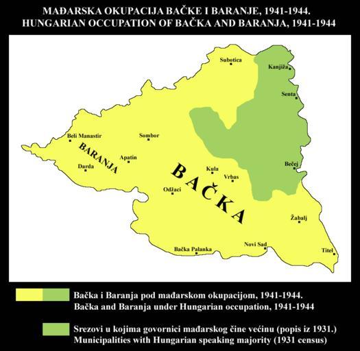
| Keywords: Madjarska okupacija Backe i Baranje, 1941-1944.png Srpski Mađarska okupacija Bačke i Baranje 1941-1944 Područje okupacije je upoređeno sa područjem srezova u kojima su govornici mađarskog bili u većini prema popisu iz 1931 Stanovništvo kojem maternji jezik nije bio mađarski činilo je većinu u najvećem delu ove teritorije koju je okupirala Mađarska Korišćeni su podaci sa popisa iz 1931 iz ovog izvora http //pod2 stat gov rs/ObjavljenePublikacije/G1931/Pdf/G19314001 pdf Jugoslovenske teritorije koje je u Drugom svetskom ratu okupirala Mađarska mogu se videti ovde http //www srpska-mreza com/MAPS/Yugoslavia/YU-Nazi-division jpg<br>English Hungarian occupation of Bačka and Baranja 1941-1944 Area of occupation is compared with area of municipalities where speakers of Hungarian were in majority according to 1931 census Population whose native language was not Hungarian formed the majority of inhabitants in most parts of this territory that was occupied by Hungary I used 1931 census data from this source http //pod2 stat gov rs/ObjavljenePublikacije/G1931/Pdf/G19314001 pdf Yugoslav territories occupied by Hungary in WW2 could be seen here http //www srpska-mreza com/MAPS/Yugoslavia/YU-Nazi-division jpg own 2011 PPetrovic 100px Maps of Yugoslavia during World War II Maps of Serbia during World War II Maps of the history of Vojvodina Maps of the history of Bačka Maps of the history of Baranja Historical maps of languages in Serbia Historical maps of languages in Vojvodina Maps in Serbian | ||||