MAKE A MEME
View Large Image

| View Original: | Map after Ptolemy's Geographia (Burney MS 111, f.15r).jpeg.jpg (5207x6832) | |||
| Download: | Original | Medium | Small | Thumb |
| Courtesy of: | commons.wikimedia.org | More Like This | ||
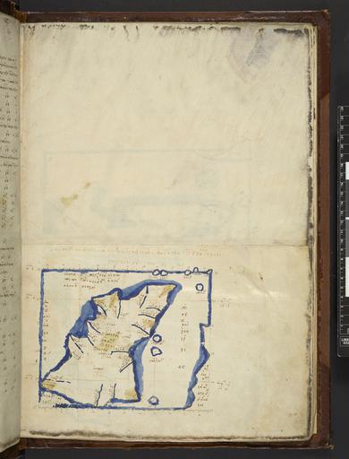
| Keywords: Map after Ptolemy's Geographia (Burney MS 111, f.15r).jpeg Hibernia The westernmost portion of the First European Map from a Greek manuscript edition of Ptolemy's Geography depicting Ireland Ivernia Island + ќЪќїќ±ѕЕќіќРќњѕЕ ќ†ѕДќњќїќµќЉќ±ќѓќњѕЕ ќУќµѕЙќ≥ѕБќ±ѕЖќєќЇбњЖѕВ бљЩѕЖќЈќ≥ќЃѕГќµѕЙѕВ ѕДбљЄ ќФќ≠ѕЕѕДќµѕБќњќљ бЉЄќњѕЕќµѕБќљќѓќ±ѕВ ќ ќЃѕГќњѕЕ ќШќ≠ѕГќєѕВ бЉЄќњѕЕќµѕБќљќєќ± ќ бњЖѕГќњѕВ ќТѕБќµѕДѕДќ±ќљќєќЇќЃ Institution British Library map date other fields Information field British Library Shelfmark Burney MS 111 f 15r other versions <gallery> File Map after Ptolemy's Geographia Burney MS 111 f 15v jpeg The central part of the map File Map_after_Ptolemy's_Geographia_ Burney_MS_111 _f 16r jpeg The eastern half of the map </gallery> PD-old print date British Library image ark /81055/vdc_100000001311 0x0000a6 A collection of maps in Greek after Ptolemy's Geography warp status wikidata location wikidata title Uploaded with GWToolset Map after Ptolemy's Geographia Burney MS 111 f 15r http //www webarchive org uk/bldatasets/MapImages/Pelagios/PtolemyGeography/burney_ms_111_f015r jpeg British Library Maps Collections Burney MS 111 015 Maps in Greek 1420 maps Ptolemy's 1st European Map 1420a Ptolemaic Ireland 1420 ImageNote 2 627 3655 2689 205 5207 6832 2 + ќЇќїќ±ѕЕќіќРќњѕЕ ѕ ѕДќњќїќµќЉќ±ќѓќњѕЕ ќ≥ќµѕЙќ≥ѕБќ±ѕЖќєќЇбњЖѕВ бљСѕЖќЈќ≥ќЃѕГќµѕЙѕВ ѕДбљЄ ќіќ≠ѕЕѕДќµѕБќњќљ <br> + Klaud√≠ou Ptolema√≠ou Ge≈НgraphikƒУs HyphƒУgƒУse≈Нs t√≤ D√©uteron ImageNoteEnd 2 ImageNote 3 1607 3803 1174 216 5207 6832 2 бЉ∞ќњѕЕќµѕБќљќѓќ±ѕВ ќљќЃѕГќњѕЕ ќЄќ≠ѕГќєѕВ <br> Iouern√≠as NƒУsou Th√©sis ImageNoteEnd 3 ImageNote 4 1367 4873 467 410 5207 6832 2 бЉ∞ќњѕЕќµѕБќљќєќ± ќљбњЖѕГќњѕВ ќ≤ѕБќµѕДѕДќ±ќљќєќЇќЃ <br> Iouernia NƒУsos BrettanikƒУ ImageNoteEnd 4 | ||||