MAKE A MEME
View Large Image

| View Original: | Map after Ptolemy's Geographia (Burney MS 111, f.16v).jpeg.jpg (5259x6887) | |||
| Download: | Original | Medium | Small | Thumb |
| Courtesy of: | commons.wikimedia.org | More Like This | ||
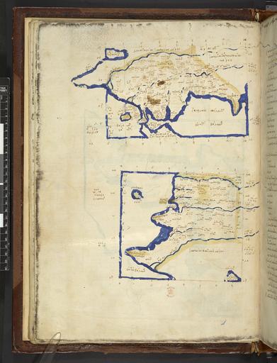
| Keywords: Map after Ptolemy's Geographia (Burney MS 111, f.16v).jpeg Hispania Baetica et Lusitania The southwestern portion of the Second European Map from a Greek manuscript edition of Ptolemy's Geography depicting Baetic Spain and Roman Portugal ß╝ĖŽāŽ ╬▒╬Į╬»╬▒Žé ╬Æ╬▒╬╣Žä╬╣╬║ß┐åŽé ╬ś╬ŁŽā╬╣ŽéĀ/ ß╝ĖŽāŽ ╬▒╬Į╬»╬▒Žé ╬ø╬┐ŽģŽā╬╣Žä╬▒╬Į╬»╬▒Žé ╬ś╬ŁŽā╬╣Žé ß╝ĖŽāŽ ßĮ░╬Į╬╣╬▒ ╬Æ╬▒╬╣Žä╬╣╬║╬Ę ╬║ßĮ░╬╣ ß╝ĖŽāŽ ╬▒╬Į╬»╬▒ ╬ø╬┐ŽģŽā╬╣ŽäßĮ░╬Į╬╣╬▒ Institution British Library map date other fields Information field British Library Shelfmark Burney MS 111 f 16v other versions <gallery> File Map after Ptolemy's Geographia Burney MS 111 f 20v jpeg northwestern portion File Map after Ptolemy's Geographia Burney MS 111 f 21r jpeg eastern half </gallery> PD-old print date British Library image ark /81055/vdc_100000001311 0x0000a6 A collection of maps in Greek after Ptolemy's Geography warp status wikidata location wikidata title Uploaded with GWToolset Map after Ptolemy's Geographia Burney MS 111 f 16v http //www webarchive org uk/bldatasets/MapImages/Pelagios/PtolemyGeography/burney_ms_111_f016v jpeg British Library Maps Collections Burney MS 111 016 1420 maps Maps in Greek Ptolemy's 2nd European Map 1420a ImageNote 1 2871 666 1240 126 5259 6887 2 ß╝░ŽāŽ ╬▒╬Į╬»╬▒Žé ╬▓╬▒╬╣Žä╬╣╬║ß┐åŽé ╬Ė╬ŁŽā╬╣Žé <br> Ispan├Łas Baitik─ōs Th├®sis ImageNoteEnd 1 ImageNote 2 2962 1148 356 184 5259 6887 2 ß╝░ŽāŽ ßĮ░╬Į╬╣╬▒ ╬▓╬▒╬╣Žä╬╣╬║╬« <br> Isp├Ānia Baitik─ō ImageNoteEnd 2 ImageNote 3 2779 2973 1114 195 5259 6887 2 ß╝░ŽāŽ ╬▒╬Į╬»╬▒Žé ╬╗╬┐ŽģŽā╬╣Žä╬▒╬Į╬»╬▒Žé ╬Ė╬ŁŽā╬╣Žé <br> Ispan├Łas Lousitan├Łas Th├®sis ImageNoteEnd 3 ImageNote 4 3732 3466 287 230 5259 6887 2 ß╝░ŽāŽ ╬▒╬Į╬»╬▒ ╬╗╬┐ŽģŽā╬╣ŽäßĮ░╬Į╬╣╬▒ <br> Ispan├Ła Lousit├Ānia ImageNoteEnd 4 | ||||