MAKE A MEME
View Large Image
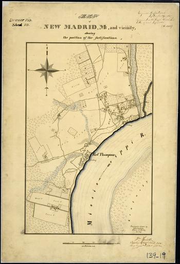
| View Original: | Map_of_New_Madrid,_Mo.,_and_Vicinity,_showing_the_position_of_the_fortifications._Surveyed_&_drawn_by_Louis..._-_NARA_-_305776.tif (3400x5000) | |||
| Download: | Original | Medium | Small | Thumb |
| Courtesy of: | commons.wikimedia.org | More Like This | ||
| Keywords: Map of New Madrid, Mo., and Vicinity, showing the position of the fortifications. Surveyed & drawn by Louis... - NARA - 305776.tif Scope and content General notes 305776 Local identifier 77-FORTS-DR139SHT19 War Department Office of the Chief of Engineers 1818 - 09/18/1947 Cartographic and Architectural Records Section Special Media Archives Services Division NWCS-C National Archives at College Park 8601 Adelphi Road College Park MD 20740-6001 ca 09/1865 Record group Record Group 77 Records of the Office of the Chief of Engineers 1789 - 1999 Record group ARC 406 Fortifications Map File Plans of Military Forts compiled 1790 - 1941 Series ARC 305749 File unit File unit ARC Variant control numbers NAIL Control Number NWDNC-77-FORTS-DR139SHT19 yes Other versions <gallery> File Map_of_New_Madrid _Mo _and_Vicinity _showing_the_position_of_the_fortifications _Surveyed_ amp _drawn_by_Louis _-_NARA_-_305776 tif tif File Map_of_New_Madrid _Mo _and_Vicinity _showing_the_position_of_the_fortifications _Surveyed_ amp _drawn_by_Louis _-_NARA_-_305776 jpg jpg </gallery> NARA-cooperation PD-USGov 1865 maps Old maps of Missouri in the American Civil War Maps of New Madrid County Missouri NARA TIF images with categorized JPGs | ||||