MAKE A MEME
View Large Image
| View Original: | Newfoundland Second Referendum 1948.png (325x334) | |||
| Download: | Original | Medium | Small | Thumb |
| Courtesy of: | commons.wikimedia.org | More Like This | ||
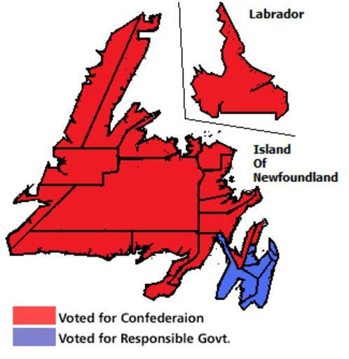
| Keywords: Newfoundland Second Referendum 1948.png election map Electoral boundaries and results of the Newfoundland referendum 1948 <br/> Based on data from map http //www heritage nf ca/law/ref1map html own Nickjbor talk created this work entirely by myself 1 12 45 26 February 2010 UTC Nickjbor talk en wikipedia Nickjbor Original upload log en wikipedia Skeezix1000 //tools wikimedia de/~magnus/commonshelper php CommonsHelper en wikipedia Newfoundland+2nd+ref+1948 png 2010-08-21 05 19 Moxy 325×334× 11659 bytes <nowiki>info was backwards</nowiki> 2010-02-26 12 45 Nickjbor 324×318× 11060 bytes <nowiki> I ~~~ created this work entirely by myself ~~~~~ ~~~ Based on data I can no longer find online Map matches this map http //www heritage </nowiki> __NOTOC__ 1948 elections in Canada 1948 in Newfoundland and Labrador 1948 maps of Canada Referendums and plebiscites in Canada Election maps of Canada Confederation | ||||