MAKE A MEME
View Large Image
| View Original: | North-Carolina-Population-Density-2008.png (1280x485) | |||
| Download: | Original | Medium | Small | Thumb |
| Courtesy of: | commons.wikimedia.org | More Like This | ||
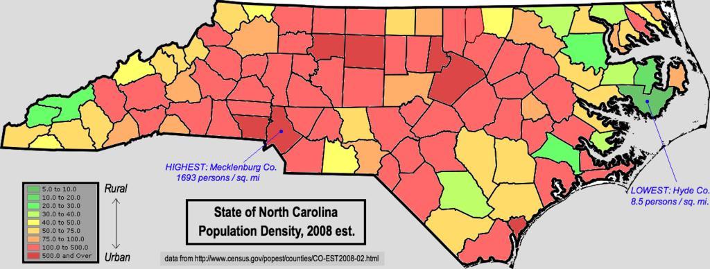
| Keywords: North-Carolina-Population-Density-2008.png Map of North Carolina using color shading to denote county-level population density using 2008 census estimates Data retrieved from http //www census gov/popest/counties/CO-EST2008-02 html Transferred from http //en wikipedia org en wikipedia; transferred to Commons by User Magnus Manske using http //tools wikimedia de/~magnus/commonshelper php CommonsHelper <br/> Original text I created this work entirely by myself FWIW though I live in Alabama now I grew up in Vance County N C May 2 2009<br/> 2009 05 02 original upload date Nuberger13 talk Original uploader was Nuberger13 at http //en wikipedia org en wikipedia Released into the public domain by the author en wikipedia Nuberger13 Original upload log page en wikipedia North-Carolina-Population-Density-2008 png 2009-05-02 22 28 Nuberger13 1280×485× 221643 bytes <nowiki> Map of North Carolina using color shading to denote county-level population density using 2008 census estimates Data retrieved from http //www census gov/popest/counties/CO-EST2008-02 html I created th</nowiki> Maps of North Carolina | ||||