MAKE A MEME
View Large Image

| View Original: | Olivehurst,_2_miles_south_of_Marysville,_Yuba_County,_California._Air_view_of_the_city_of_Marysville_._._._-_NARA_-_521573.tif (3000x2259) | |||
| Download: | Original | Medium | Small | Thumb |
| Courtesy of: | commons.wikimedia.org | More Like This | ||
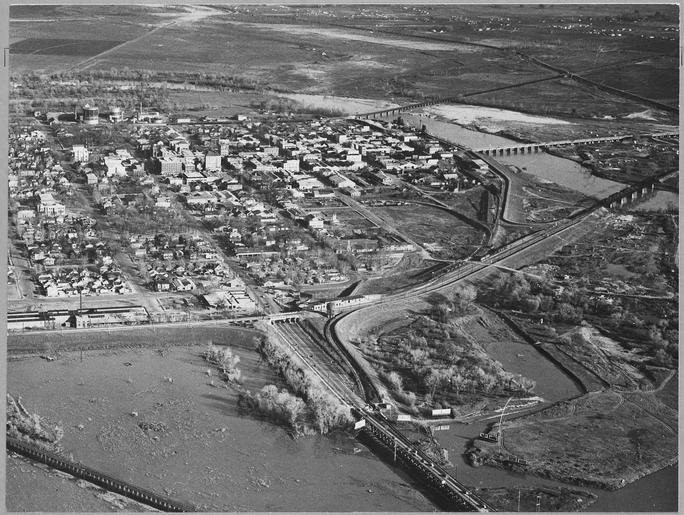
| Keywords: Olivehurst, 2 miles south of Marysville, Yuba County, California. Air view of the city of Marysville . . . - NARA - 521573.tif Scope and content Full caption reads as follows Olivehurst 2 miles south of Marysville Yuba County California Air view of the city of Marysville population 5 763 county seat of Yuba County The rural shacktown of Olivehurst is situated two and one-half miles from this town beyond the incorporated district Marysville is now the trading center of the important peach growing section of the Sacramento Valley Established in 1848 it was a boom town during the early mining days The squatter settlement photographed is located on the right bank of middle bridge or D St Bridge A fast developing rural shacktown Linda seen in distance at right General notes 521573 Local identifier 83-G-41332 Department of Agriculture Bureau of Agricultural Economics Division of Economic Information ca 1922 - ca 1953 NARA-Author Lange Dorothea 1895-1965 Photographer 1372774 <br /> Still Picture Records Section Special Media Archives Services Division NWCS-S National Archives at College Park 8601 Adelphi Road College Park MD 20740-6001 01/1940 Record group Record Group 83 Records of the Bureau of Agricultural Economics 1876 - 1959 Record group ARC 412 Photographic Prints Documenting Programs and Activities of the Bureau of Agricultural Economics and Predecessor Agencies compiled ca 1922 - ca 1947 documenting the period ca 1911 - ca 1947 Series ARC 521048 File unit File unit ARC Variant control numbers NAIL Control Number NWDNS-83-G-41332 yes Other versions <gallery> File Olivehurst _2_miles_south_of_Marysville _Yuba_County _California _Air_view_of_the_city_of_Marysville_ _ _ _-_NARA_-_521573 tif tif File Olivehurst _2_miles_south_of_Marysville _Yuba_County _California _Air_view_of_the_city_of_Marysville_ _ _ _-_NARA_-_521573 jpg jpg </gallery> NARA-cooperation PD-USGov NARA TIF images with categorized JPGs California Dorothea Lange | ||||