MAKE A MEME
View Large Image

| View Original: | Piney Creek Ravine highlights.png (303x622) | |||
| Download: | Original | Medium | Small | Thumb |
| Courtesy of: | commons.wikimedia.org | More Like This | ||
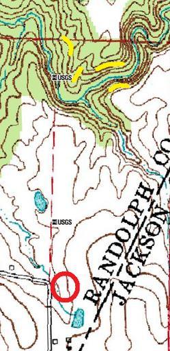
| Keywords: Piney Creek Ravine highlights.png Piney Creek Ravine State Natural Area in southeastern Randolph County Illinois Randolph County Illinois United States The red circle is the parking area while the four yellow locations are petroglyph sites From left to right they are Tegtmeyer Site Tegtmeyer Piney Creek West Site Piney Creek West Piney Creek Site Piney Creek main Piney Creek South Site Piney Creek South Parking area location is derived from the uploader's experience visiting the site; petroglyph locations are derived from the citations at http //en wikipedia org/w/index php oldid 545578478 this edition of the English Wikipedia's article National Register of Historic Places listings in Randolph County Illinois Map is a creation of the United States Geological Survey with site markings made by uploader 2013-04-09 United States Geological Survey and User Nyttend Map and modifications respectively PD-USGov-USGS Maps of Randolph County Illinois Piney Creek Ravine State Natural Area Maps by User Nyttend | ||||