MAKE A MEME
View Large Image

| View Original: | Planungsvariante K12-5.png (1202x960) | |||
| Download: | Original | Medium | Small | Thumb |
| Courtesy of: | commons.wikimedia.org | More Like This | ||
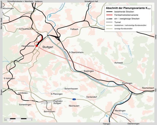
| Keywords: Planungsvariante K12-5.png en A map of the variant K 12 5 for a Stuttgart-Ulm high-speed railway line A ~20 km tunnel between Stuttgart and the area of Plochingen with a four-track station underneath a 16-track terminus to be kept was a key element of this variant While only the greater Stuttgart area is depicted on the map this line would have continued to Ulm The route is derived from the plans for the official approval process The underlying map is based on Karte_Stuttgart_21_aussen_Kartenwerkstatt svg a public domain map by K Jähne kjunix <br />While existing rail lines are depicted in black the new high-speed line is in red Dotted lines are used for tunnels de Karte zur nicht realisierten Planungsvariante K 12 5 für eine Schnellfahrstrecke zwischen Stuttgart und dem Raum Ulm Dargestellt ist der Großraum Stuttgart mit dem Fernbahntunnel Stuttgart gestrichelt der bis Ulm führenden Strecke Die Informationen stammen aus den Planfestellungsunterlagen zur Ausbau- und Neubaustrecke Stuttgart-Augsburg Teil B Bereich Kirchheim-Weilheim-Aichelberg von 1997 Die Karte basiert auf der gemeinfreien Datei Karte_Stuttgart_21_aussen_Kartenwerkstatt svg von K Jähne kjunix own Stoeffler 2011-04-22 Cc-zero Maps of project Stuttgart 21 | ||||