MAKE A MEME
View Large Image
| View Original: | Red_River,_Louisiana_Deposits1.jpg (5341x6771) | |||
| Download: | Original | Medium | Small | Thumb |
| Courtesy of: | commons.wikimedia.org | More Like This | ||
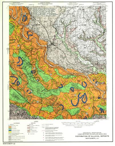
| Keywords: Red River, Louisiana Deposits1.jpg Red River of the South in Montgomery Louisiana 15-minute quadrangle showing classic examples of modern and abandoned prehistoric meander belts within Grant and Natchitoches parishes Louisiana This map illustrates the relationship between meandering river courses abandoned channels and associated point bar and natural levee deposits of the Red River Latitude 31 668104 Longitude -92 890531 ;Credits Smith F L and D P Russ 1974 Geological investigation of the lower Red River-Atchafalaya Basin area Lower Mississippi Valley Technical Report No S-74-5 US Army Engineer Waterways Experiment Station Vicksburg MS http //lmvmapping erdc usace army mil/Atcha htm 2011-06-05 US Army COE Technical Report No S-74-5 F L Smith and D P Russ PD-USGov Red River of the South Maps of Grant Parish Louisiana Red Maps of Natchitoches Parish Louisiana Red Meanders Meanders in the United States Fluvial deposits | ||||