MAKE A MEME
View Large Image

| View Original: | Rise and Fall of the Ottoman Empire 1300-1923.gif (1104x834) | |||
| Download: | Original | Medium | Small | Thumb |
| Courtesy of: | commons.wikimedia.org | More Like This | ||
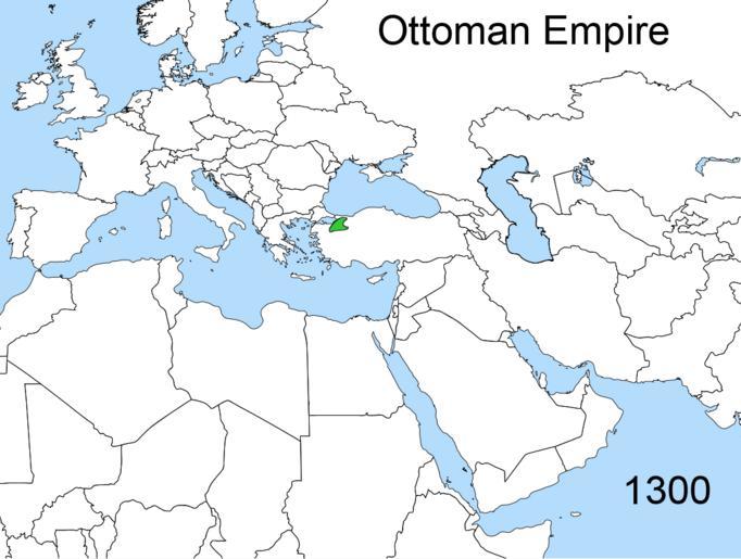
| Keywords: Rise and Fall of the Ottoman Empire 1300-1923.gif image information Rise and Fall of the Ottoman Empire 1300-1923 Fact disputed Own Created April 2008 Esemono ąÆ čäą░ą╣ą╗ąĄ ą┐č ąĖčüčāčéčüčéą▓čāąĄčé ąŠčłąĖą▒ą║ą░- čāą║ą░ąĘą░ąĮąŠ čćč鹊 č鹥č č ąĖčéąŠč ąĖčÅ čüąŠą▓č ąĄą╝ąĄąĮąĮąŠą│ąŠ ąÉąĘąĄč ą▒ą░ą╣ą┤ąČą░ąĮą░ ą▓čģąŠą┤ąĖą╗ą░ ą▓ čüąŠčüčéą░ą▓ ąĖą╝ą┐ąĄč ąĖąĖ čü 1683-ą│ąŠ ą┤ąŠ 1817-ą╣ ą│ąŠą┤čŗ ą ą░ čüą░ą╝ąŠą╝ ąČąĄ ą┤ąĄą╗ąĄ čāąČąĄ ą▓ 1723-ą╝ ą│ąŠą┤čā ą▓ąŠčüč鹊čćąĮą░čÅ ą┐č ąĖą║ą░čüą┐ąĖą╣čüą║ą░čÅ čćą░čüčéčī ąÉąĘąĄč ą▒ą░ą╣ą┤ąČą░ąĮą░ ą┐ąŠą┐ą░ą╗ą░ ą┐ąŠą┤ ą║ąŠąĮčéč ąŠą╗čī ąĀąŠčüčüąĖąĖ ą┐ąŠčüą╗ąĄ ąÜą░čüą┐ąĖą╣čüą║ąŠą│ąŠ ą┐ąŠčģąŠą┤ą░ ą¤ąĄčéč ą░ I ąĖ ą┐ąŠą┤ą┐ąĖčüą░ąĮąĮąŠą│ąŠ čü ąśč ą░ąĮąŠą╝ ą┤ąŠą│ąŠą▓ąŠč ąŠą╝ ; ą░ ą▓ 1735-ą╝ ą×čüą╝ą░ąĮčüą║ą░čÅ ąĖą╝ą┐ąĄč ąĖčÅ ą┐č ąĖąĘąĮą░ą╗ą░ ąÉąĘąĄč ą▒ą░ą╣ą┤ąČą░ąĮ č鹥č č ąĖčéąŠč ąĖąĄą╣ ąśč ą░ąĮą░ čŹč鹊 ąŠčäąĖčåąĖą░ą╗čīąĮąŠ ą▒čŗą╗ąŠ ą┐č ąĖąĘąĮą░ąĮąŠ ą▓ ą┤ąŠą│ąŠą▓ąŠč ą░čģ 1736 1746 ą│ąŠą┤ąŠą▓ European and non-European areas marked in different colors; German labels English labels still on deactivated layers <br /> 250px European and non-European areas marked in different colors; German labels; only 1830-1923 <br /> 250px Without language specific heading below the 12 5 million pixel rule <br /> 250px Interactive animated SVG variant with some language switches <br /> 400px <gallery> File Territorial_changes_of_the_Ottoman_Empire_1300 jpg File Territorial_changes_of_the_Ottoman_Empire_1359 jpg File Territorial_changes_of_the_Ottoman_Empire_1451 jpg File Territorial_changes_of_the_Ottoman_Empire_1481 jpg File Territorial_changes_of_the_Ottoman_Empire_1520 jpg File Territorial_changes_of_the_Ottoman_Empire_1566 jpg File Territorial_changes_of_the_Ottoman_Empire_1639 jpg File Territorial_changes_of_the_Ottoman_Empire_1672 jpg File Territorial_changes_of_the_Ottoman_Empire_1683 jpg File Territorial_changes_of_the_Ottoman_Empire_1699 jpg File Territorial_changes_of_the_Ottoman_Empire_1718 jpg File Territorial_changes_of_the_Ottoman_Empire_1739 jpg File Territorial_changes_of_the_Ottoman_Empire_1774 jpg File Territorial_changes_of_the_Ottoman_Empire_1783 jpg File Territorial_changes_of_the_Ottoman_Empire_1792 jpg File Territorial_changes_of_the_Ottoman_Empire_1798 jpg File Territorial_changes_of_the_Ottoman_Empire_1801 jpg File Territorial_changes_of_the_Ottoman_Empire_1812 jpg File Territorial_changes_of_the_Ottoman_Empire_1817 jpg File Territorial_changes_of_the_Ottoman_Empire_1829 jpg File Territorial_changes_of_the_Ottoman_Empire_1830 jpg File Territorial_changes_of_the_Ottoman_Empire_1862 jpg File Territorial_changes_of_the_Ottoman_Empire_1878 jpg File Territorial_changes_of_the_Ottoman_Empire_1881 jpg File Territorial_changes_of_the_Ottoman_Empire_1882 jpg File Territorial changes of the Ottoman Empire 1912 corrected jpg File Territorial_changes_of_the_Ottoman_Empire_1913 jpg File Territorial_changes_of_the_Ottoman_Empire_1913b jpg File Territorial_changes_of_the_Ottoman_Empire_1920 jpg File Territorial_changes_of_the_Ottoman_Empire_1923 jpg </gallery> Animated maps of the Ottoman Empire Animated maps showing changing boundaries over time London protocol | ||||