MAKE A MEME
View Large Image

| View Original: | Sibiu County 1937.svg (2604x2213) | |||
| Download: | Original | Medium | Small | Thumb |
| Courtesy of: | commons.wikimedia.org | More Like This | ||
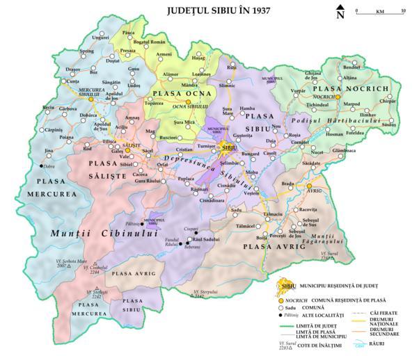
| Keywords: Sibiu County 1937.svg Assessments 1 en Sibiu County in 1937 Harta Judeţului Sibiu aşa cum arăta în 1937 English Own work by uploader Sources 1 3rd Military Mapping Survey of Austria-Hungary 1910-1915 http //commons wikimedia org/wiki/File Nagy-Szeben_-_42-46 jpg http //commons wikimedia org/wiki/File Gyula-Fehérvár_-_41-46 jpg 2 The ethnic maps of the 1930 Romanian Census for the names and exact location of the settlements and their administrative borders http //commons wikimedia org/wiki/File Sibiu-Hermannstadt_ ethnic JPG http //commons wikimedia org/wiki/File Gyula-Fehérvár_ ethnic _ JPG 3 The following two maps for the internal divisions of the county and other features http //romaniainterbelica memoria ro/judete/sibiu/harta_judet_sibiu jpg http //sebok1 adatbank transindex ro/legbelso php3 nev erd1941 - although this is a 1941 map the divisions are the same as in 1937 Română Hartă realizată de către uploader Surse 1 A treia revizie cartografică a Austro-Ungariei 1910-1915 http //commons wikimedia org/wiki/File Nagy-Szeben_-_42-46 jpg http //commons wikimedia org/wiki/File Gyula-Fehérvár_-_41-46 jpg 2 Următoarele hărţi etnice ale recensământului din 1930 pentru numele limitele administrative şi poziţia exactă a localităţilor http //commons wikimedia org/wiki/File Sibiu-Hermannstadt_ ethnic JPG http //commons wikimedia org/wiki/File Gyula-Fehérvár_ ethnic _ JPG 3 Următoarele două hărţi pentru diviziunile interne ale judeţului şi alte detalii http //romaniainterbelica memoria ro/judete/sibiu/harta_judet_sibiu jpg http //sebok1 adatbank transindex ro/legbelso php3 nev erd1941 - chiar dacă este o hartă din 1941 împărţirea administrativă a judeţului este aceiaşi ca în 1937 Own work 2009-01-31 http //ro wikipedia org/wiki/Fişier Sibiu_County_1937 png Atlas entries in progress fase 9 SVG maps of Romania Interwar Sibiu County 1937 | ||||