MAKE A MEME
View Large Image
| View Original: | The_Quarterly_journal_of_the_Geological_Society_of_London_(14053360366).jpg (1183x2018) | |||
| Download: | Original | Medium | Small | Thumb |
| Courtesy of: | commons.wikimedia.org | More Like This | ||
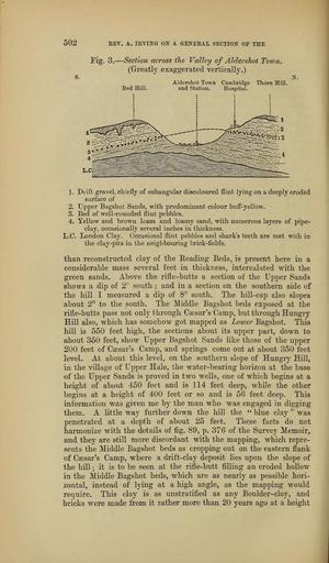
| Keywords: The Quarterly journal of the Geological Society of London (14053360366).jpg 502 <br> EEV A lEYIXG OX A GE2fEEAL SECTION' OE TKE <br> Fig 3 ” Section across the Valley of Aldershot Toiun <br> Greatlv exaggerated vertically <br> 8 X <br> Aldershot Town Cambridge Thorn Hill <br> Eed Hill and Station Hospital <br> 1 Diift graxel chiefly of subangular discoloured flint lying on a deeply eroded <br> surface of <br> 2 Upper Bagshot Sands with predominant colour buff-yellow <br> 3 Bed of well-rounded flint pebbles <br> 4 Yellow and brown Icam and loamy sand with numerous layers of pipe- <br> clay occasionally several inches in thickuess <br> L C London Clay Occasional flint pebbles and shark's teeth are met with in <br> the clay -pits in the neighbouring brick-fields <br> than reconstructed clay of the Eeading Beds is present here in a <br> considerable mass several feet in thickness intercalated with the <br> green sands Above the rifle-butts a section of the Upper Sands <br> shows a dip of 2 south ; and in a section on the southern side of <br> the hill I measured a dip of 8° south The hill-cap also slopes <br> about 2° to the south The Middle Bagshot beds exposed at the <br> rifle-butts pass not only through Caesar's Camp but through Hungry <br> Hill also which has somehow got mapped as Loiuer Bagshot This <br> hill is 550 feet bigh the sections about its upper part down to <br> about 350 feet show Upper Bagshot Sands like those of the upper <br> 200 feet of Caesar's Camp and springs come out at about 350 feet <br> level At about this level on the southern slope of Hungry Hill <br> in the village of Upper Hale the water-bearing horizon at the base <br> of the Upper Sands is proved in two wells one of which begins at a <br> height of about 450 feet and is 114 feet deep while the other <br> begins at a height of 400 feet or so and is bQ feet deep This <br> information was given me by the man who was engaged in digging <br> them A little way further down the hiR the blue clay was <br> penetrated at a depth of about 2o feet These facts do not <br> harmonize with the details of fig 89 p 376 of the Survey Memoir <br> and they are still more discordant with the mapping which repre- <br> sents the Middle Bagshot beds as cropping out on the eastern flank <br> of Caesar's Camp where a drift-clay deposit lies upon the slope of <br> the hill ; it is to be seen at the rifle-butt filling an eroded hoUow <br> in the Middle Bagshot beds which are as nearly as possible hori- <br> zontal instead of lying at a high angle as the mapping would <br> require This clay is as unstratified as any Boulder-clay and <br> bricks were made from it rather more than 20 years ago at a height 37047380 114009 51125 Page 502 Text 41 http //www biodiversitylibrary org/page/37047380 1885 Geological Society of London Biodiversity Heritage Library The Quarterly journal of the Geological Society of London v 41 1885 Geology Periodicals Smithsonian Libraries bhl page 37047380 dc identifier http //biodiversitylibrary org/page/37047380 smithsonian libraries Information field Flickr posted date ISOdate 2014-04-30 Check categories 2015 August 26 CC-BY-2 0 BioDivLibrary https //flickr com/photos/61021753 N02/14053360366 2015-08-26 04 51 15 cc-by-2 0 PD-old-70-1923 The Quarterly journal of the Geological Society of London 1885 Photos uploaded from Flickr by Fæ using a script | ||||
.jpg)