MAKE A MEME
View Large Image

| View Original: | The_Quarterly_journal_of_the_Geological_Society_of_London_(12683199255).jpg (1203x2106) | |||
| Download: | Original | Medium | Small | Thumb |
| Courtesy of: | commons.wikimedia.org | More Like This | ||
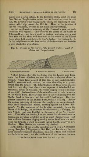
| Keywords: The Quarterly journal of the Geological Society of London (12683199255).jpg 1856 <br> HARKNESS PERMIAN ROCKS OF SCOTLAND <br> 2bl <br> matrix is of a softer nature In the Ryecastle Burn about two miles <br> from Nether Cleugh station where the two formations come in con- <br> tact the newer is found resting on the older and consisting of sand- <br> stones which dip toward the W S W Here at the junction of <br> the two formations breccias do not make their appearance <br> At the north-eastern extremity of the Corncockle area the sand- <br> stones are well exposed They occur in the course of the Annan at <br> Johnston Bridge and have a south inclination ; and when we go west <br> from this we find them well developed in the course of the Kinnel <br> Burn about half a mile below St Ann's Bridge See Section fig 1 <br> In this neighbourhood the best section of the sandstones and breccias <br> is seen which this area affords <br> Fig 1 ” Section in the course of the Kinnel Water Parish of <br> Johnstone Dumfriesshire <br> \\\V \A wk \\A Vv A\\ <br> c False-bedded sandstones <br> b Breccias and sandstones <br> a <br> a Silurian rocks <br> A short distance above the foot-bridge over the Kinnel near Eliza- <br> town the Lower Silurians are seen with the sandstones almost in <br> contact These latter consist of thin beds of red sandstone false- <br> bedded associated with breccias the latter abounding to a greater <br> extent than the former The total thickness of these strata exceeds <br> 100 feet; and they have above them deposits of false-bedded red <br> sandstone devoid of breccias ; the whole dipping south at an angle <br> of about 30° Red sandstones of the same character occur in the course <br> of the Mollin Burn They are seen also on the road leading from the <br> Moffat Road to Courance and have a S E inclination They also <br> present themselves in the Burrans Burn with a S S E dip And at <br> the western extremity of this area the conglomerate occurs immedi- <br> ately under Kirkmichael Manse abutting against the Lower Silu- <br> rians To the south-east of this locality immediately below the <br> Water of Ae bridge the sandstone likewise occurs ; it is flaggy and <br> dips N N E ; and near Trailflat in the course of the Ae it is also <br> seen From this last locality I am not aware that the sandstones or <br> breccias are anywhere exhibited until we reach Rammerscales ; and <br> here we have the strata dipping north ; and at Smallholm the sand- <br> stone was formerly worked to a small extent but the quarry is now <br> filled up Here likewise the northern dip obtained <br> In the interior of this area the sandstone is well seen at Corncockle <br> quarry Templand Village quarry Red Hall and Lochbrow ; the two <br> latter quarries being now abandoned In none of these four localities <br> are the breccias seen ; but the sandstones of the two quarries now <br> See Section Quart Journ Geol Soc vol xi p 469 35338710 109655 51125 Page 257 Text v 12 http //www biodiversitylibrary org/page/35338710 1856 Geological Society of London NameFound Rammerscales Biodiversity Heritage Library The Quarterly journal of the Geological Society of London v 12 1856 Geology Periodicals Smithsonian Libraries bhl page 35338710 dc identifier http //biodiversitylibrary org/page/35338710 smithsonian libraries Information field Flickr posted date ISOdate 2014-02-21 Check categories 2015 August 26 CC-BY-2 0 BioDivLibrary https //flickr com/photos/61021753 N02/12683199255 2015-08-27 11 57 22 cc-by-2 0 PD-old-70-1923 The Quarterly journal of the Geological Society of London 1856 Photos uploaded from Flickr by Fæ using a script | ||||