MAKE A MEME
View Large Image
| View Original: | Tombstone_lithograph_map_shootout.png (489x631) | |||
| Download: | Original | Medium | Small | Thumb |
| Courtesy of: | commons.wikimedia.org | More Like This | ||
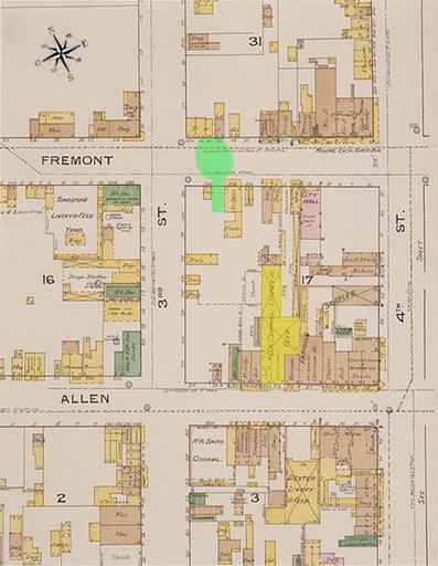
| Keywords: Tombstone lithograph map shootout.png 18 ft wide lot highlighted in green on Fremont Street between Fly's Photography Studio and the Harwood House and spread onto Fremont Street The O K Corral itself highlighted in yellow is located on Allen St The gunfight took place six lots west of the rear entrance to the corral This map is one of over 700 000 fire insurance map sheets produced by the Sanborn Map Company for more than twelve thousand American cities and towns from the 1870s until the 1950s These maps were prepared primarily to assist insurance underwriters in determining the risk involved in insuring individual properties The outline or footprint of each building is indicated and the buildings are color coded to show the construction material pink for brick; yellow for wood; brown for adobe Numbers inside the lower right corner of each building indicate how many stories the building had while the numbers outside the building on the street front refer to the street addresses allowing researchers to correlate these locations with census records and city directories Individual dwellings are marked with D or Dwg http //www loc gov/exhibits/treasures/trr016 html Library of Congress New York Sanborn Map and Publishing Company 1886 Tombstone fire insurance map of Tombstone Arizona 600px left 31 42 50 N 110 04 03 W region US-AZ_type event PD-USGov Tombstone Arizona Maps of Arizona | ||||