MAKE A MEME
View Large Image
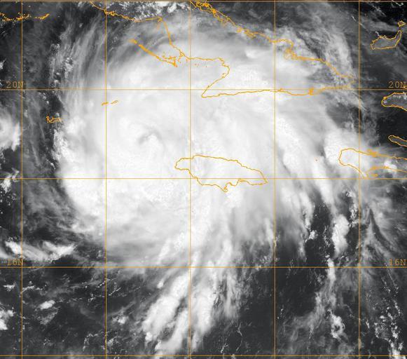
| View Original: | US_Navy_080829-N-0000W-001_A_GOES-12_infrared_satellite_image_provided_by_the_U.S._Naval_Research_Laboratory,_Monterey,_Calif.,_showing_the_status_of_Tropical_Storm_Gustav_at_approximately_11_am_EST.jpg (1024x902) | |||
| Download: | Original | Medium | Small | Thumb |
| Courtesy of: | commons.wikimedia.org | More Like This | ||
| Keywords: US Navy 080829-N-0000W-001 A GOES-12 infrared satellite image provided by the U.S. Naval Research Laboratory, Monterey, Calif., showing the status of Tropical Storm Gustav at approximately 11 am EST.jpg en CARIBBEAN SEA Aug 29 2008 A GOES-12 infrared satellite image provided by the U S Naval Research Laboratory Monterey Calif showing the status of Tropical Storm Gustav at approximately 11 am EST Gustav is a tropical storm on the Saffir-Simpson hurricane scale with maximum sustained winds near 65 mph and higher gusts The storm is currently in the Caribbean Sea The storm is moving north by northwest at 8 mph with its track taking it across the western tip of Cuba into the Gulf of Mexico and making landfall somewhere on the U S Gulf Coast by Monday morning U S Navy photo Released 2008-08-29 080829-N-0000W-001 Navy http //www navy mil/view_image asp id 63253 U S Navy photo PD-USGov-Military-Navy Hurricane Gustav GOES 12 pictures Satellite pictures of hurricanes | ||||