MAKE A MEME
View Large Image

| View Original: | Utm-zones.jpg (2048x1024) | |||
| Download: | Original | Medium | Small | Thumb |
| Courtesy of: | commons.wikimedia.org | More Like This | ||
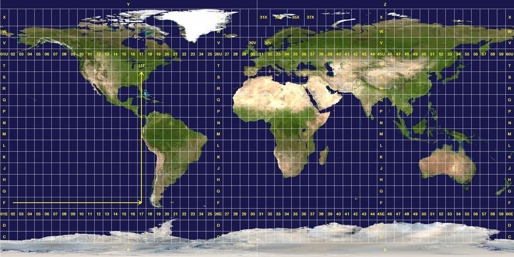
| Keywords: Utm-zones.jpg Universal Transverse Mercator system Longitude zones are six degrees wide They are numbered from 01 at 180° west increasing towards the east until 60 at 180° east Latitude zones are 8° high They are lettered from C to X omitting the letters I and O beginning at 80° south The letters A B Y and Z are used in the polar regions by the Universal Polar Stereographic grid system A grid reference is read right up as indicated by the arrows A reference is always written with the longitude zone first In this example 17T Exceptions to the system are apparent The west coast of Norway is given a wider zone 32V taking some space from the zone 31V that covers open water The zones around Svalbard are also widened effectively deleting some longitude zones at this latitude Finally the entire latitude zone X is extended an extra 4° topping off at 84° north PD-USGov This image was constructed from a public domain Visible Earth product of the Earth Observatory office of the United States government space agency NASA It is based on a cylindrical equi-distant projection and was marked up by custom software created specifically for the Wikipedia GFDL-en relicense Universal Transverse Mercator coordinate system Blue Marble Next Generation images Topographic maps of the world Global maps centered Greenwich Language-neutral maps | ||||