MAKE A MEME
View Large Image

| View Original: | Vojvodina10.svg (940x968) | |||
| Download: | Original | Medium | Small | Thumb |
| Courtesy of: | commons.wikimedia.org | More Like This | ||
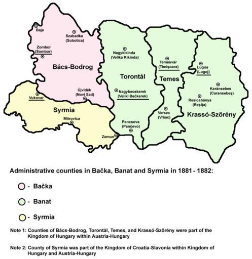
| Keywords: Vojvodina10.svg BadSVG historic map of counties in Ba─Źka Banat and Syrmia in 1881-1882 self made <br>Serbian ąĖčüčéąŠč ąĖčśčüą║ą░ ą╝ą░ą┐ą░ ąČčāą┐ą░ąĮąĖčśą░ čā ąæą░čćą║ąŠčś ąæą░ąĮą░čéčā ąĖ ąĪč ąĄą╝čā 1881-1882 ą│ąŠą┤ąĖąĮąĄ en Category Maps of the history of Vojvodina en ja Vojvodina10 jpg Vojvodina10 png 2009-10-03 16 54 UTC Vojvodina10 png PANONIAN wikipedia en derivative work Rrburke <span class signature-talk >talk</span> Converted to SVG Rrburke Vojvodina10 png PD-user-w Original upload log This image is a derivative work of the following images File Vojvodina10 png licensed with PD-user-w 2009-03-31T15 08 45Z PANONIAN 940x968 83683 Bytes <nowiki></nowiki> 2009-03-12T10 09 09Z PANONIAN 980x869 70310 Bytes <nowiki></nowiki> 2008-04-07T17 15 43Z File Upload Bot Magnus Manske 600x420 120437 Bytes <nowiki> en wikipedia historic map self made en Category Maps of the history of Vojvodina en ja Vojvodina10 jpg Transferred from http //en wikipedia org</nowiki> Uploaded with derivativeFX B├Īcs-Bodrog County Syrmia County Toront├Īl County Temes County Krass├│-Sz├Čr├®ny County Maps of Austria-Hungary Maps of the history of Banat Maps of the history of Ba─Źka Maps of the Ottoman period in the history of Serbia Maps of the Habsburg period in the history of Serbia Maps of the history of Syrmia Maps of the history of Vojvodina | ||||